 Pedestrians enjoying the riverwalk, alongside the floodwalls, with Con Edison’s East River Generating Station in the background. Image Credits: BIG
The East River Generation Station sits on the edge of a historically working-class, immigrant neighborhood of tenement blocks and housing projects. The homes are separated from the river by little more than a narrow strip of park and the scenic FDR Drive parkway. But the risk the river poses is changing. During the years since Sandy, engineers and construction crews have turned the power plant into what Jamie Brennan, Con Edison’s vice president of engineering, calls “a fortress” surrounded by floodwalls and massive floodgates. The neighborhood is also getting protection: The local park is being rebuilt as a flood barrier.
Today, Con Edison is preserving the control room flooded by Sandy’s waters, as a kind of museum to the night the river came in. Wilson, the substation operator that night, walks visitors through the room. “It rose about this high,” he says, holding his hand at his waist. “All our electrical components down here were flooded.” In 2017, Con Edison moved the control room upstairs to a new, elevated facility. Outside, concrete walls and watertight doors now wrap the campus. Critical control wiring rides on tracks that operators hand-crank into the air 48 hours before the next big storm. New transformers sit on concrete pedestals 14 to 17 feet up.
Just beyond Con Edison’s perimeter, the city’s wall is rising, too. The engineering firm Arcadis designed a 2.4-mile stretch of the East Side Coastal Resiliency project running from East 25th Street south to Montgomery Street, just below the Williamsburg Bridge. When completed, the barrier will be a continuous line of concrete walls, raised parks, and 18 massive floodgates. To design the gates, Arcadis used Bentley Systems’ STAAD structural engineering and analysis software, building virtual replicas that the team could test in extreme situations.
Speed mattered, too. Roni Deitz, Arcadis’s global director of climate adaptation, says the software cut her team’s design time from 30 hours per gate to 30 minutes, while letting them simulate everything from storm-surge waves to a multi-ton garbage truck riding the flood and slamming into a gate. “Anything that could come at it, we need to be prepared for,” she says.
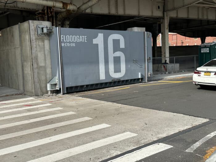 East Side Coastal Resiliency project floodgate
Most New Yorkers will never see those gates closed, as they should be sheltering in a safe place when the next Sandy hits. To bring the system to a wider audience, Bentley sent photographer Aaron Huey to document the new infrastructure. Not with an ordinary camera, but with a 3D rig that produces Gaussian splats, a new and revolutionary way of capturing real-world spaces in three dimensions.
Named for Carl Friedrich Gauss, the mathematician whose name graces the bell curve, the splats are mathematical functions that render each point in a scene as a soft, semi-transparent blob rather than a hard dot. Each splat carries data about its position, color, size, transparency, and orientation. Layered together, millions of them can reconstruct a 3D scene with striking realism, capturing thin wires, reflections, and even glass that changes appearance as the viewer moves around it—details that traditional polygon-based graphics often miss.
To reconstruct the area around the plant, Bentley’s emerging technologies team, known as Bentley Labs and led by Greg Demchak, combined Huey’s splats with artificial intelligence (AI) and Unreal Engine, the gaming software now widely used in cinema and visual effects. Working from Huey’s captures of the old flooded control room, the new flood walls and the gates around the nearby Asser Levy Playground, the team built an immersive experience that lets a viewer watch the water rise to the level it reached the night of Sandy, then close the gates and see the new defenses hold.
“Seeing is believing,” says Markus Sauerbeck, a senior developer in Bentley Labs who worked on the visualization. “We are using the latest emerging technology to let people understand much easier why these massive infrastructure projects are necessary for New York’s citizens.”
Bentley recently presented the visualizations, which can be viewed in Apple Vision Pro, at London’s ATN conference and the Illuminate 2026 conference in Berlin. Plans are also in the works to bring the visualizations to New York.
 A 3D map shows Lower Manhattan with highlighted areas indicating the 100-year floodplain boundaries near the river and bridge. Image Credits: BIG
“These models,” Huey says, “let us simulate what it looks like when the next Sandy arrives”—and what it will look like when, this time, the wall holds.
 An illustration showing the boundaries created by the flood walls. Image Credits: BIG