NAKSHA project
Organization: C.E. Info Systems Limited (MapmyIndia)
Project Name: National Geospatial Knowledge-based Land Survey of Urban Habitations (NAKSHA)
Location: Rajasthan, India
Project Scale: 450 square kilometers across five cities, consisting of hundreds of thousands of high-resolution UAV images
Projected ROI: 75% reduction in processing hours, 30% to 35% project cost savings, 100% geometric consistency, 75% decrease in server energy consumption
Bentley Software: iTwin Capture
Project: Processing a 450 square kilometer urban digital twin for Rajasthan
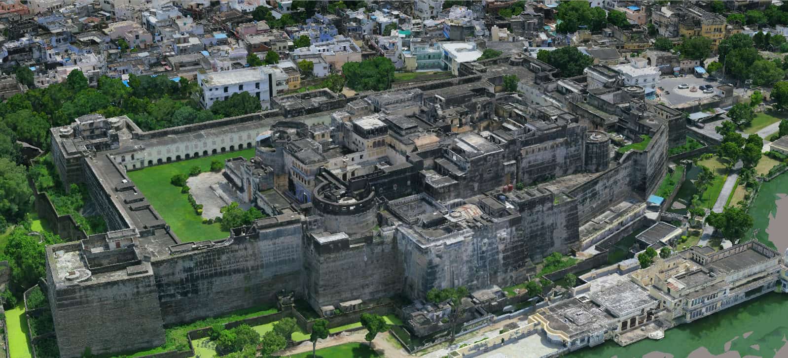
As part of the NAKSHA initiative, India is pushing to create high-resolution national digital twins of its urban landscapes. To execute this vision in the state of Rajasthan, the government partnered with C.E. Info Systems Limited (MapmyIndia), a leading geospatial tech company, to map 450 square kilometers across five key cities (Behror, Bagru, Bhiwadi, Sawai Madhopur, and Kishangarh).
Tasked with creating a centimeter-level accurate 3D reality model to support smart city governance, disaster management, and infrastructure monitoring, MapmyIndia faced unprecedented technical hurdles. The massive volume of high-resolution drone imagery threatened to overwhelm local hardware.
Initially, the team attempted to use conventional photogrammetry platforms. However, legacy software simply could not handle the scale. The team was forced to partition the cities into dozens of smaller sub-blocks or “chunks.” This fragmented approach caused severe bottlenecks, system crashes, and manual edge-matching errors where the data blocks failed to align properly, putting the project’s aggressive government deadlines at risk.
Facts: Faster geospatial data processing for city digital twins
- Unprecedented speed: By processing massive datasets in a single execution, MapmyIndia achieved a 75% reduction in total project processing time.
- Massive cost efficiency: Eliminating the manual labor required to stitch and fix fragmented data blocks drove 30% to 35% savings in total project costs.
- Flawless precision: Processing entire cities as a single entity eliminated alignment risks, ensuring 100% geometric consistency across the 450 sq. km area.
- Sustainable IT: Shaving months off the computing timeline resulted in a 75% reduction in server energy consumption and associated compute-related carbon emissions.
“The NAKSHA project faced a massive bottleneck: merging fragmented city data into a usable whole. Bentley’s iTwin Capture engines solved this by allowing us to process entire city in one go. This breakthrough eliminated the risk of data misalignment and saved months of manual labor. In the Indian context, where urban density and rapid growth demand high precision data, Bentley iTwin technology has provided us with the speed, scale, and accuracy with necessary to deliver world-class digital infrastructure ahead of schedule.”
— Mr. Anil Jangir, AVP – 3D Digital Twin, C.E. Info Systems Limited (MapmyIndia)
Solution: Processing UAV imagery with iTwin Capture in one workflow
To overcome the limitations of legacy tools, MapmyIndia needed an enterprise-grade processing engine capable of handling extreme data volumes without faltering. They found their solution by adopting iTwin Capture.
Bentley’s technology provided a highly optimized, scalable processing environment capable of handling hundreds of thousands of aerial images in one integrated workflow. The key differentiator was iTwin Capture’s ability to process massive volumes of data in a unified environment without requiring manual segmentation.
By running the data in one go, MapmyIndia bypassed the labor-intensive chunking process entirely. iTwin Capture easily navigated the complex environments of dense urban canyons, automatically resolving lighting inconsistencies and occlusions to generate a seamless, highly accurate 3D mesh.
Outcome: Seamless 3D reality meshes for urban planning
MapmyIndia’s digital strategy delivered a measurable, state-wide impact. By leveraging iTwin Capture, the team delivered five complete, flawless city models in the time that it would normally take to complete just one or two using traditional methods. The 75% reduction in processing time freed up thousands of work hours and directly slashed project costs by 30% to 35%.
Beyond financial metrics, this efficiency translated into a massive sustainability win. Because servers were not running for months to process and stitch fragmented tiles, the project’s digital carbon footprint and cooling requirements plummeted by 75%.
Today, the high-fidelity 3D reality meshes provide a seamless digital foundation for the Survey of India’s National Spatial Data Infrastructure (NSDI). Shared via a single web-based interface, this interoperable digital twin empowers local municipalities with a holistic, error-free view of their cities—enabling accurate property tax assessments, flood modeling, and sustainable urban planning for years to come.
Software used:
iTwin Capture: Served as the core reality modeling engine, utilizing scalable, multiengine processing to synthesize hundreds of thousands of drone images into a seamless 3D mesh without the need for data fragmentation.
Process city-scale reality data without fragmenting workflows
Stop letting valuable reality data sit in disconnected silos or crash your hardware. Just like MapmyIndia, your organization can turn massive, fragmented datasets into a governed, enterprise-wide spatial layer. With iTwin Capture, infrastructure teams can securely process, manage, and share enormous reality datasets with unparalleled speed and scale. Automate your workflows, eliminate data-stitching errors, and maximize the ROI of your reality capture investments today.