In the world of water infrastructure, the challenges are clear. Aging systems, tightening regulations, and the increasing frequency of extreme weather events demand that engineers and utilities work faster and smarter than ever before. Yet, engineering teams are often held back by disconnected workflows and manual and repetitive tasks.
What if you could interact with your hydraulic model the same way you talk to a colleague? What if your model could seamlessly connect to the entire project ecosystem, breaking down data silos for good?
The latest release of OpenFlows 2026 transforms the hydraulic modeling experience. By integrating AI-powered assistance, deepening the connection to digital twins, eliminating spatial data headaches, and streamlining results analysis, OpenFlows 2026 empowers engineers to analyze, design, and operate water, sewer, and storm networks with greater efficiency and confidence.
This release includes a number of new capabilities designed to streamline daily modeling work and enhance project-wide collaboration. Here is a closer look at what’s new, along with the practical benefits these features bring to your workflows.
AI-powered hydraulic modeling with Bentley Copilot
Hydraulic modeling software is inherently complex, packed with hundreds of tools, settings, and commands. Traditionally, navigating these capabilities meant hunting through menus, consulting extensive documentation, or tapping on a senior colleague’s shoulder.
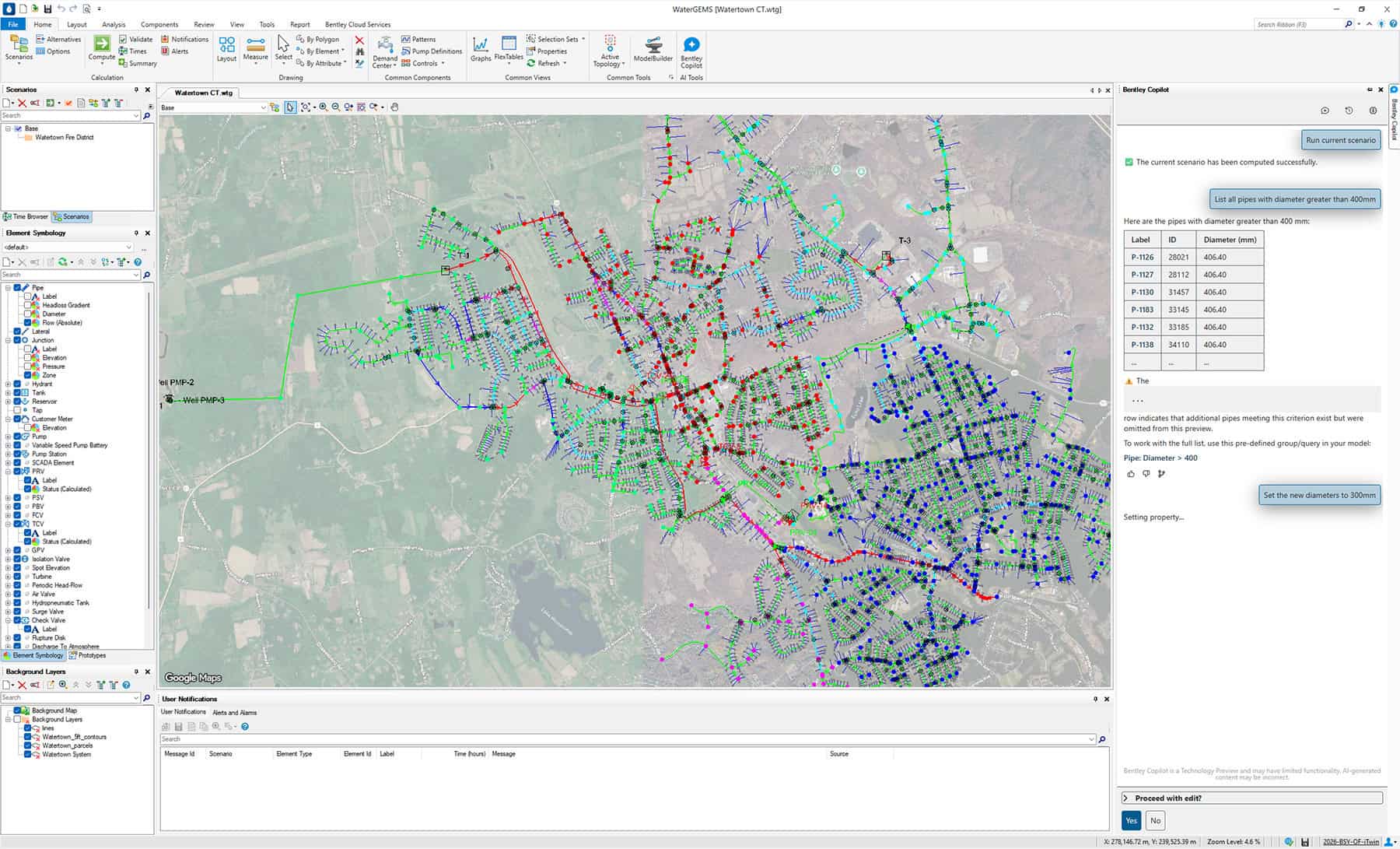
OpenFlows 2026 introduces Bentley Copilot (available as a Technology Preview) integrated directly into your modeling workspace. Bentley Copilot is an intelligent, AI-driven assistant that allows you to interact with your model using plain, natural language, including your own native language.
It reduces manual tasks and minimizes errors so engineers can work more efficiently and spend more time on high-value analysis and decision-making.
Instead of searching for a specific button or trying to remember how to build a complex query, you can simply ask Copilot to do it for you. You can use it to:
- Query model data: Ask Bentley Copilot to “Find all pipes with a diameter over 300mm and a velocity greater than 1.5 m/s.”
- Launch ribbon commands and perform simple edits: Ask it to “Select these elements and change their material to ductile iron” or “open the fire flow alternatives manager.”
- Get instant “how do I” answers: “How do I set up a pump control based on tank elevation?” or “Explain what this specific user notification means.”
The practical impact of Bentley Copilot is twofold. For new engineers, it drastically reduces the learning curve, allowing them to become productive members of the team much faster. For seasoned modelers, it eliminates the friction of routine software navigation. By translating natural language requests into software actions, Bentley Copilot streamlines your daily modeling, making your workflows significantly easier and faster.

Connect hydraulic models to digital twins and iModels
Historically, hydraulic models have existed in siloes. A modeler builds the network model, runs the analysis, and extracts the data into a report or a spreadsheet to share with the rest of the project team. Because the model itself is locked in specialized software, non-modelers, such as project managers, civil engineers, and external stakeholders, rarely get to interact with the rich spatial and operational data it contains.
OpenFlows 2026 breaks down these disciplinary walls through enhanced digital twin and iModel connectivity.
You can now easily publish and share your water, sewer, and stormwater network models directly to the Bentley Infrastructure Cloud. This transforms your hydraulic model from a standalone file into an accessible, collaborative digital asset.
By bringing your model into the Bentley Infrastructure Cloud, you enable true cross-discipline collaboration. Stakeholders can view the hydraulic networks in rich 2D or 3D environments alongside other critical infrastructure, such as roadways, structural foundations, and existing utilities. This unified view makes it easier to conduct multidiscipline reviews, communicate design intent, and spot potential physical clashes or design inconsistencies long before construction begins. The result is a more coordinated project delivery process that minimizes risk and rework.

Expanded coordinate system support
Ask any hydraulic modeler what the most tedious part of setting up a new model is, and you will likely hear about spatial data alignment. Bringing background maps, GIS data, and elevation terrains often requires the use of third-party GIS software to reproject the files into a single, matching coordinate system. This is a manual, error-prone process that distracts from actual engineering work.
OpenFlows 2026 solves this challenge with comprehensive, native expanded coordinate system support.
The software can automatically detect, or allow you to specify, coordinate systems for all external data sources directly within the OpenFlows interface. Whether you are importing GIS shapefiles, integrating terrain models, pulling live data from SCADA systems, connecting to ArcGIS portals, or simply overlaying Google Maps backgrounds, OpenFlows handles the spatial alignment on the fly.
You no longer need to leave OpenFlows or rely on external GIS specialists to prepare your data. The software automatically reprojects your data sources to match your model’s designated coordinate system. This results in drastically faster model setup times and allows you to move straight into the analysis phase.

Advanced 2D reporting and scenario annotation
Building and running a model is only half the job—the real value lies in interpreting the results. When evaluating different design alternatives or operational strategies, modelers often have to flip back and forth between different scenarios, exporting data to external spreadsheets just to compare the outcomes. Analyzing complex 2D results for stormwater or flooding also requires highly visual tools to truly understand the behavior of the system.
OpenFlows 2026 introduces enhancements to how you visualize and report on the complex 2D surface results. The release introduces instant 2D grid cell graphing and the ability to easily generate reporting transects across your 2D mesh.
The new annotation tools allow you to create labels and visual callouts that are specific to individual scenarios. As a result, you can display results from multiple scenarios side-by-side directly on your model canvas.
Being able to view multiple scenario annotations simultaneously allows for instant, visual side-by-side comparisons of different design alternatives. The new 2D grid and transect reporting tools make it easy to extract meaningful data from complex surface flow results. Together, these features streamline the evaluation process, helping you draw accurate conclusions and accelerate your final engineering analysis.

Advance your water infrastructure modeling with OpenFlows 2026
The enhancements in OpenFlows 2026 are not just new features—they are direct responses to the real-world challenges faced by our users. By integrating AI assistance with daily tasks, connecting models to digital twins for broader collaboration, automating spatial data management, and upgrading analytical reporting, we are helping utilities and engineering firms work more efficiently than ever before.
See how OpenFlows 2026 helps utilities and engineering teams accelerate hydraulic modeling, improve digital twin collaboration, and streamline water, sewer, and stormwater network analysis and design.