Co-Authors: Rua Suleiman, and Luís Fernandes
Flash floods in urban areas are becoming increasingly common, causing widespread devastation and loss of life. Floods can come about at any time of the year and their occurrences are influenced by various factors. Whether due to seasonal hurricanes or typhoons in coastal regions or local heavy rainfall or cloudbursts, these floods can overwhelm drainage systems and rivers while driving water accumulation in lower areas. Human intervention is also a factor, as dam failures, levee breaches, or urban development that alters natural drainage patterns have increased potential to cause catastrophic damages.
The recent event in Libya was a severe flash flood that highlighted the urgent need to plan and use all the advanced technologies available—such as Bentley’s OpenFlows FLOOD, OpenFlows SewerGEMS, and OpenFlows CivilStorm—with 2D flood modeling capabilities to mitigate such disasters. In this blog, we will dive into the reasons behind flash floods in urban cities, look at technical experts using the technology, and share how flood events can be avoided and mitigated if the right measures are taken.
The Need to Change How We Plan Cities
As cities grow, natural surfaces are replaced by impermeable ones, such as roads, pavements, and buildings. This replacement prevents rainwater from being absorbed into the ground, leading to rapid runoff and flooding. Also, urban drainage systems in many cities are aging, outdated, or poorly maintained. Ineffective and insufficient stormwater infrastructure worsens the problem, significantly impacting its capability to handle heavy rainfall.
A common trend in urban planning for new cities is the focus on increasing green areas, low-impact development (LID), and nature-based solutions, acting on increasing water retention and infiltration to reduce the high flooding risks. The study of sustainable stormwater management practices can be modeled inside OpenFlows SewerGEMS and OpenFlows CivilStorm, such as assigning catchments to different LID types, including bioretention swales and driveway pavement. This capability can help understand the proposed solution’s impact and allow for decisions based on modeled studies.
The Libya Flash Flood Event
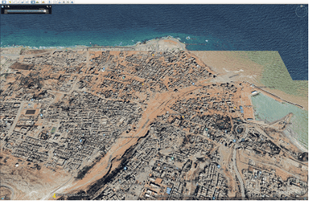
In September 2023, Libya experienced a devastating flash flood event that affected many cities. The most affected was Derna, where extreme and persistent rainfall over the catchment draining to Wadi Derna quickly produced high river flows, resulting in the failure of two dams upstream of the city and its consequent catastrophic flood event.
The reasons behind this event were largely rooted in a combination of extensive urbanization and insufficient drainage control, ineffective infrastructure maintenance, and unusual weather patterns. It has brought to light the critical need for advanced flood management technologies.
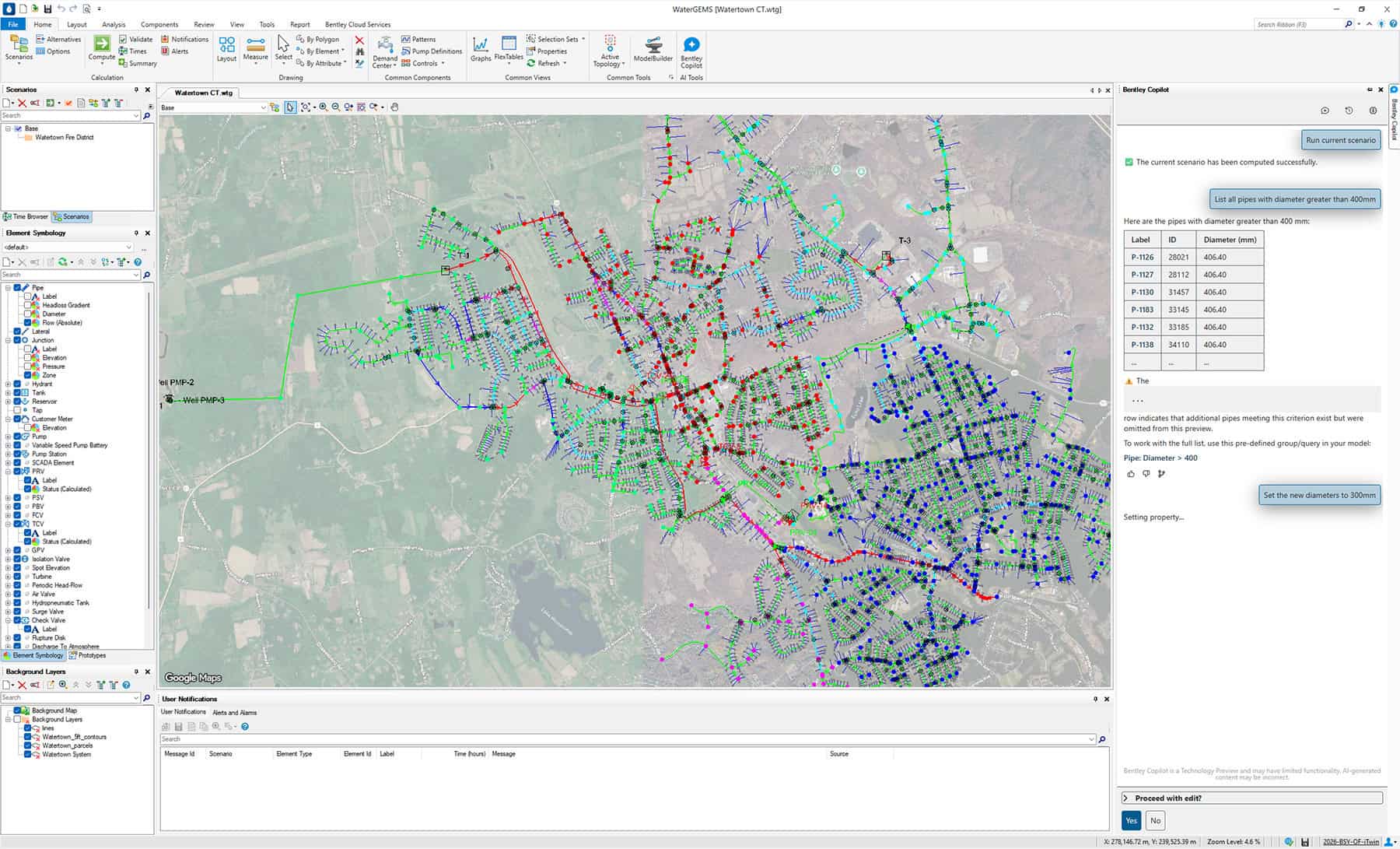
Bentley’s OpenFlows applications offer two main solutions to address these issues. OpenFlows FLOOD is a complete flood modeling software for understanding and mitigating flood risks in urban, riverine, and coastal areas. It uses fully spatially distributed numerical models to simulate all hydrological and hydraulic processes that occur in river basins, including rainfall, infiltration, surface runoff, channel flow, and groundwater flow. It dynamically simulates water depth, flow intensity, and direction to produce accurate mapping of flood-prone areas due to extreme rainfall or ruptured dams or levees.
OpenFlows SewerGEMS is a state-of-the-art hydraulic modeling software to simulate water flow in sewer and stormwater drainage systems in urban environments. It has recently been extended to simulate 2D overland flow and provide accurate insights on how surface flow interacts with subsurface drainage systems to identify systems pitfalls, allowing engineers to provide an inclusive risk management plan.
But how can these solutions help mitigate urban flash floods in urban areas?
OpenFlows SewerGEMS allows engineers to create precise models of a city’s stormwater systems. This accuracy is crucial for identifying potential trouble spots and flood-prone areas. Engineers can simulate various scenarios to understand how different factors—such as rainfall intensity and drainage improvements—impact flooding. This capability assists in designing better infrastructure and urban planning.
On the other hand, OpenFlows FLOOD can simulate full watershed hydrological processes (rainfall, runoff, infiltration, soil/groundwater flow, river routing) based on real or synthetic storm events and provide an accurate representation of river/wadi flows. Also, if the river has a flow control structure, such as a dam, OpenFlows FLOOD can simulate a wave from a dam break and map the resulting flood. Ultimately, these river flows can be used in high-resolution models, either in OpenFlows FLOOD or OpenFlows SewerGEMS, to calculate flood risk maps and delineate mitigation strategies by setting up alternative scenarios where these strategies are digitally represented in a model and their effectiveness verified.
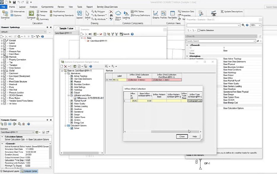
The powerful Scenario Manager capability in OpenFlows SewerGEMS can be used to plan for climate change adaptation studies. It helps engineers and urban planners assess the resilience of storm systems in their cities and develop strategies to mitigate its impacts on weather by proposing network expansion, adding new ponds, and identifying locations required for maintenance on the specific part of the network. Scenario Manager can incorporate all these different proposals by having multiple scenarios that represent various climate change projections. These scenarios may include changes in rainfall patterns, increased intensity of storms, and altered runoff characteristics due to climate change. Engineers can analyze the modeled results to identify vulnerabilities in the storm system that may arise due to climate change situations. For example, they can determine areas at risk of flooding or storm overflows during extreme weather events.
The Scenario Manager capability also provides analysis to assess whether the existing storm infrastructure can handle projected climate-related challenges. Engineers can simulate the impact of implementing green infrastructure solutions, increasing pipe sizes to balance between cost and capacity, or modeling LID, such as retention swales, to reduce flood risks. This analysis can be viewed in charts or graphs for professional results presentations by comparing the network capacity and costs of different mitigation strategies under various climate scenarios. This data-driven approach to climate change adaptation ensures that decisions are based on scientific modeling and analysis, rather than making assumptions or waiting for heavy storms to discover vulnerable areas. Below is a picture of the OpenFlows SewerGEMS Scenario Comparison tool.
Analyzing the Libya Flash Flood Event
As we look closer at the flood event in Libya, we see the importance of using advanced hydrological/hydraulic applications to review and analyze stormwater drainage in an integrated way. It is the only way to be prepared and minimize the impact of flooding.
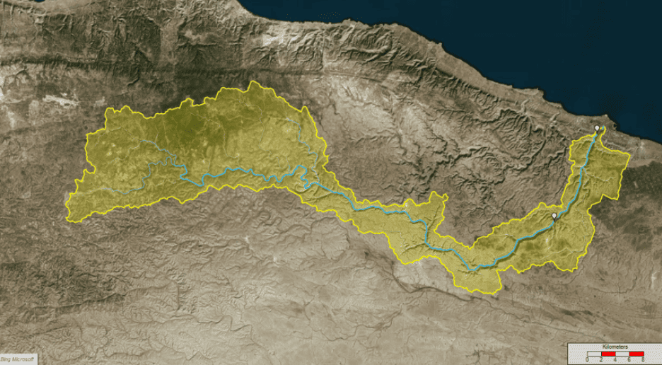
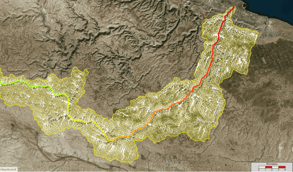
Using available open-source data, it is possible to quickly prepare a crude simulation of the Libya events. Using NASA’s SRTM terrain elevation data of roughly 30 meters resolution, we can delineate the watershed draining to the Wadi Derna and compute the natural drainage network with OpenFlows FLOOD. In the image below, the yellow area shows the Wadi Derna watershed, and the blue lines represent the drainage water lines. The two white markers represent the two dams that were destroyed.
The natural drainage network consists of a network of open channels where rainwater is routed from a 2D overland flow model. Simple trapezoidal cross-sections were assumed with a width derived from Bing maps aerial photos and depth derived from the terrain model. A simple assumption was made that the river cross-sections can accommodate all the flow resulting from runoff in the catchment.
Rainfall data was used from a local weather station in Derna, estimated around 200 millimeters of rainfall in 24 hours. Because it is local rainfall in the city, it is not representative of the rainfall over the watershed, so ECMWF ERA5 hourly rainfall data was used as a more conservative estimation of around 70 millimeters in 24 hours.
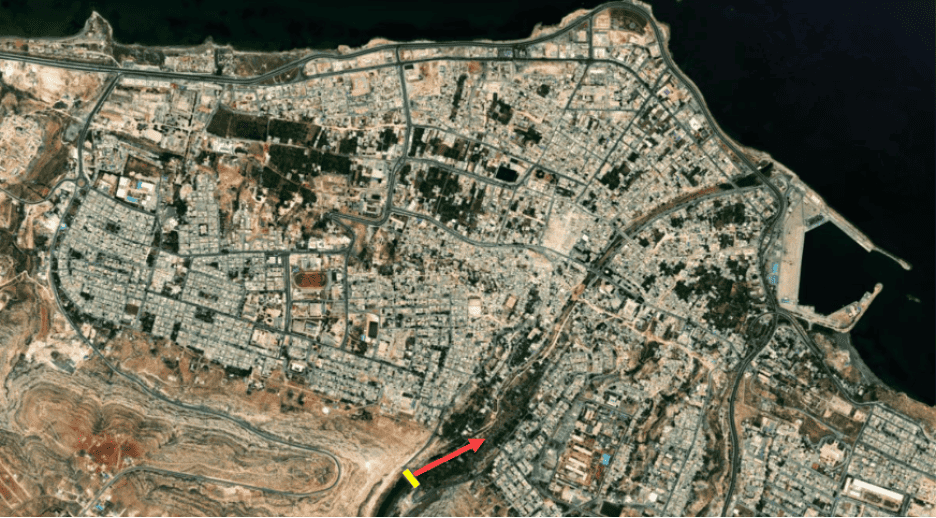
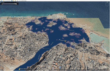
A quick rainfall-runoff scenario was simulated, assuming no infiltration and no hydraulic control structures such as dams. A mean sea level fixed water elevation boundary condition was assumed at the outlet. In the image below, the yellow polygon represents the catchment boundary. White arrows represent the direction of flow over the terrain surface. Colored lines (red, yellow, and blue) represent river flow intensity (red being higher near the outlet of the natural drainage network).
The natural flows that were generated by the rainfall event over the catchment ranged between 700 cubic meters per second and 1,800 cubic meters per second when using ERA5 rainfall data and local rainfall gauge, respectively. On its own, the lower flow rate is sufficient to burst the wadi margins in the urban area of Derna.
The total volume generated from rainfall-runoff exceeds 2 to 5 times the design storage volumes of both dams (1.5 million and 18 million cubic meters, respectively). The dams were severely overtopped and destroyed during the event.
A supplementary, yet straightforward, high-resolution simulation was conducted, utilizing the same basic open-source data.
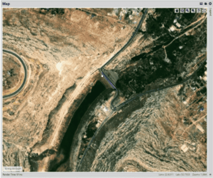
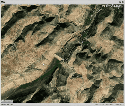
In this simulation, a computational grid with a resolution of 5 meters was set up to cover the city of Derna. Notably, for the sake of simplicity, the grid’s terrain elevations did not incorporate buildings or any other infrastructure elements. To evaluate potential flood scenarios, an upstream flow boundary condition was entered at the dam located near the city’s southern end, as shown in the picture below.
Two simple scenarios were considered. In the first scenario, we only used the modeled natural flow, as determined by the hydrological simulation, without the presence of any dams. The first scenario demonstrated that even in the absence of dam controls, there was high flow generated from the simulation, resulting in significant inundation, as shown in the below video.
Conversely, in the face of increasingly intense rainfall events and rapid urbanization, city planners worldwide must prioritize a comprehensive review of their drainage and flood control systems. Even in situations where data may be limited or of low resolution, valuable insights can be gleaned by examining natural drainage patterns to assess the potential for flooding.
Furthermore, employing specialized capabilities, such as dam break analysis in OpenFlows FLOOD, becomes crucial. This software enables the modeling of catastrophic events, allowing for a deep understanding of the risks associated with critical infrastructure failures, particularly when the safety and well-being of the population are at stake.
Conclusion
The increasing frequency and severity of flash floods in urban areas are posing significant challenges, leading to widespread devastation and loss of life. These events can be triggered by various factors, including intense rainfall, seasonal hurricanes/typhoons, and human interventions, such as dam failures and urban development that alter natural drainage patterns.
The recent flash flood event in Libya, particularly in Derna, serves as a stark reminder of the urgent need for comprehensive flood management strategies to prepare for and minimize the impact of flooding. These technologies such as OpenFlows FLOOD and OpenFlows SewerGEMS, when used even with available open-source data, can provide valuable insights into flood events, their causes, and potential mitigation strategies and more accurate results when used with higher quality data. As urbanization continues to grow and extreme weather events become more common, adopting these tools is imperative to protect our communities and infrastructure from the devastating effects of flash floods.
If you want to look up past blogs, go to https://blog.bentley.com/category/hydraulics-and-hydrology/.