For this midwestern city located in Iowa, it all started with a need for accessibility. Sven Peterson, city administrator for Perry, wanted to make sure his rural town of 7,929 people met Americans with Disabilities Act (ADA) requirements so that all residents could easily traverse the streets. “Our job at the City of Perry is to improve people’s quality of life,” he said. “We want to make Perry a better and easier place to live.”
He never imagined that his desire for ADA compliance would result in creating a digital twin of the entire town, giving one of the smallest towns in the United States a digital twin of its roads, buildings, sidewalks, and other vital assets. Through the creation of a digital twin, city planners are able to gather an array of valuable information in one place and provide the basis for developing many types of improvement projects.
Peterson began thinking about implementing digital technologies when he started planning how the city could conduct a full-scale ADA assessment. The biggest hurdle to full compliance was ensuring that pedestrian ramps blended seamlessly with sidewalks and roads, pathways remained well-maintained, and all assets stayed within a maximum slope to ensure easy passage for all. Not all of the existing passageways met those standards, but Perry officials had no way of knowing what assets fell short or the amount of work that was needed.
Perry had never undertaken a citywide ADA assessment – until recently, ramps and sidewalks were assessed one by one, and as needed. Peterson wanted to make the process easier and evaluate all passageways at once, which would save time and create a unified database that would provide easy ADA compliance and up-to-date information for future progress.
While Peterson was thinking about how to overcome the issue, he met Dave Overman, project land survey specialist with Foth Infrastructure & Environment, at a professional development conference. Overman, also based in Iowa, was familiar with the area, and the two shared their latest work. Overman said that Foth had incorporated advanced mobile LiDAR image scan technology into their service portfolio, which could help cities in a variety of ways – including meeting ADA compliance. “When I brought up ADA compliance, I got his attention,” Overman said.
Though it was unusual for a town the size of Perry to use mobile LiDAR scans, Peterson wanted to take a proactive approach and assemble all data at once, rather than try to do it piece by piece. “The great thing about this scanning project is that you only have to scan once,” Peterson said. “You then have that data on hand and can use it for hundreds of other applications.”
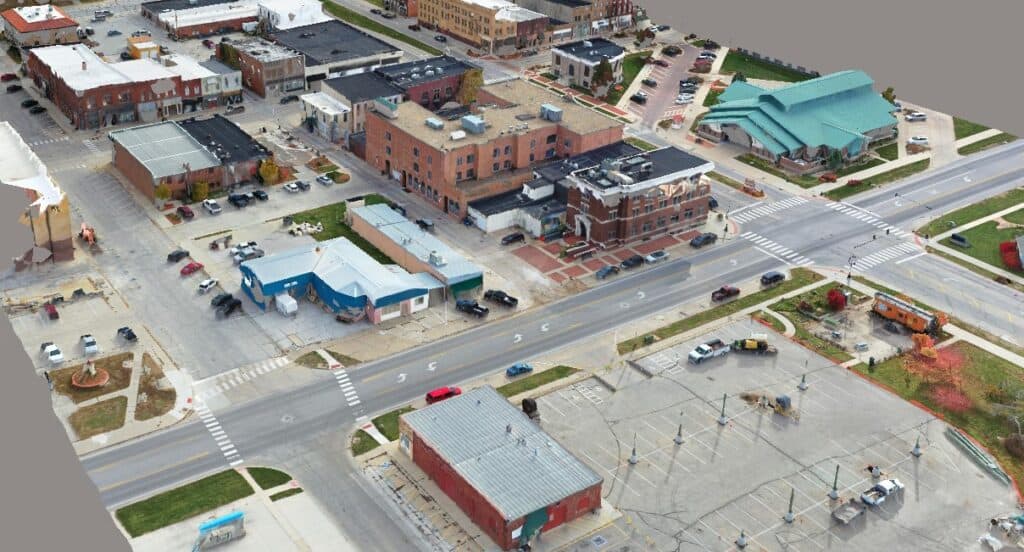 Foth processed 4.1 terabytes of information, into a detailed 3D reality mesh of the town.
Creating Digital Twins Before the Last Minute
As Overman, Peterson, and their colleagues planned the project, the scope continued to grow. Since they were sending out a mobile LiDAR unit to capture images of street curbs, they thought – why not capture images of other assets as well? They could easily expand the capture to take in traffic signs, trees, buildings, and other elements of the city, without significantly increasing the project cost.
Though Peterson was not initially familiar with the concept of creating a detailed digital twin of an entire city, he quickly realized the potential for a digital twin to encourage the city’s development and improve the quality of life for residents. “We started having conversations and brainstorming how else this [project] could be used for the community, and how it could help us with the issues we face,” he said. Overman said Foth already wanted to expand their imaging projects and make them more useful. Though the company had long created detailed digital twins of projects to ensure that they are as accurate and efficient as possible, the digital twins were only created to support specific projects. For example, a client would direct Foth to create a digital twin of a busy section of a highway when that highway was scheduled for an expansion. In many cases, clients wanted Foth to start the surveying process immediately – even if imaging teams were already booked, or weather conditions made surveying difficult. “We’ve had projects where we’ve had to use blowtorches and pickaxes to break through snow and ice to get to the actual road,” he said.
“A neighboring town had a tornado, which did a lot of damage to one of their historic buildings. They had to try to rebuild it just by using old photos. If one of our buildings gets damaged, we [now] have digital replicas of them.”
– Sven Peterson, city administrator for Perry
As a result, teams at Foth dreamed of having digital twins available ahead of time, Overman said. Not only would that eliminate the scramble to create reality models at the last minute, but Foth and the client could also potentially use them for other purposes over time. A digital twin of a highway could not only help teams plan an expansion but could also provide stakeholders with valuable context for determining how to create safe pedestrian paths or green spaces long after the initial expansion was finished.
As a proof of concept, Foth wanted to create a digital twin of an entire town. Though the imaging process would be a significant undertaking, such a digital twin could support a multitude of projects, with ADA compliance just the start. A municipal digital twin could provide the blueprint for future development, disaster preparedness, flood control, or emergency vehicle dispatch, for example. It could even jumpstart future projects that otherwise would not happen by clearly demonstrating to potential investors what is possible. With the city of Perry’s project, Foth finally had the opportunity to create an ongoing, city-scale digital twin. Peterson convinced other city officials of the vast possibilities and won both their approval and their enthusiasm. “Our council and mayor are great at seeing the bigger picture and the direction we’re headed,” he said.
However, because small towns have limited resources compared to bigger cities, Foth had to make the capture and development process as efficient and cost-effective as possible. The imaging and design team also wanted to be prepared, as Foth had never developed a municipal digital twin before. “This was the largest project we had done so far,” Overman said.
Digital Twin Brings Real-World Benefits
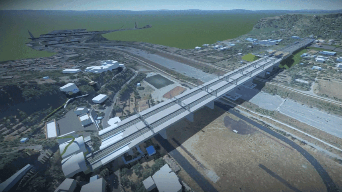
Before collecting images, the team planned the route of the scanning vehicle to eliminate duplicate work and ensure that they captured all needed data the first time. Over the next three days, the Foth team drove a vehicle equipped with LiDAR scanners through Perry’s streets, capturing 375,788 images of streets, sidewalks, buildings, signs, trees, and other assets. During capture, a command center performed quality control checks to make sure all data was consistent and accurate. Over the following months, they processed all the imagery, totaling 4.1 terabytes of information, into a detailed 3D reality mesh of the town.
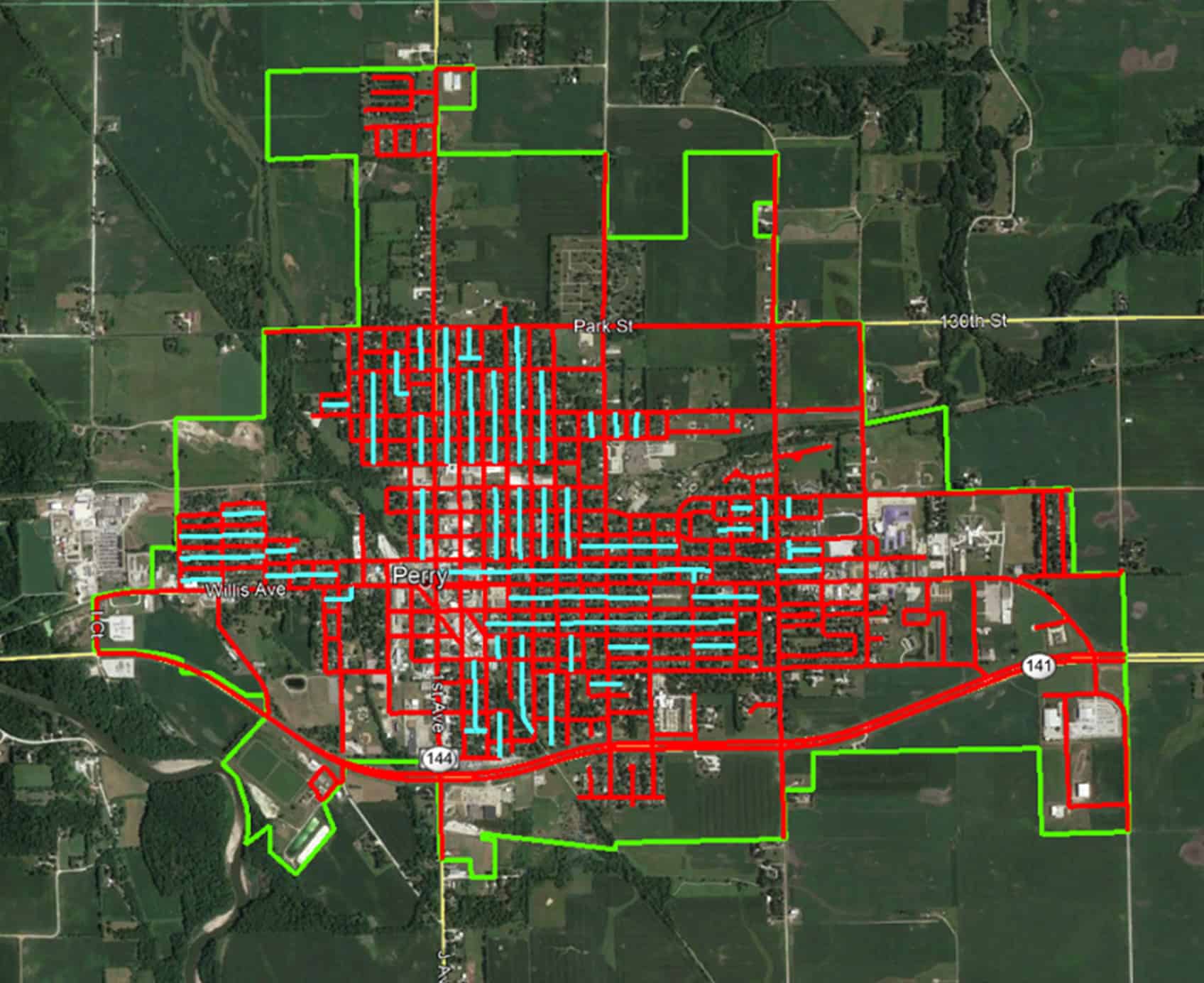 Imaging scan of routes throughout the City of Perry.
With the help of efficient applications and Foth’s careful planning, Perry received a full digital twin of the town, created with the same amount of money originally earmarked for the ADA compliance project alone. Peterson and his colleagues are already putting the digital twin to use. They anticipate the digital twin will help the city enact its Comprehensive Plan 2030 – a package of infrastructure initiatives that will support Perry’s small-town identity while building big-city connections – 60% faster.
RELATED: City Revitalizes Neighborhoods with Complete Streets Design
Peterson also plans to use the digital twin to help the town recover from severe weather events. An August 2020 derecho wreaked havoc on central Iowa, causing severe damage to buildings and destroying more than 7 million trees. Perry’s digital twin includes a tree inventory, which will help the city assess damage in future events and quickly replace lost trees. Detailed digital imagery of buildings can assist with repairing structural storm damage. “A neighboring town had a tornado, which did a lot of damage to one of their historic buildings,” he said. “They had to try to rebuild it just by using old photos. If one of our buildings gets damaged, we [now] have digital replicas of them.”
Attracting Incentives to Kickstart Projects
Perry’s downtown is part of the National Register of Historic Places, an honor that brings tax incentives, as well as the responsibility to meet the register’s standards. Peterson anticipates that the digital twin will increase the city’s ability to adhere to the tax incentives program by 50%, as well as improve historic building renovations and inspections by 25%.
These initiatives could just be the beginning and could lead to many other projects in the future. For example, Peterson wants to use the digital twin as the basis for an autonomous public transportation system that could serve the elderly and other groups that lack their own transportation. Whatever the project, he anticipates the digital twin will make receiving state and federal funding easier, as it will help them put together compelling, 3D presentations and demonstrate their ability to bring these projects into reality. “We want to continue to understand the full breadth of what the data can be used for,” Peterson said. “We’re just scratching the surface of how the data can be used.”
As for Foth, the company intends to use Perry as a pilot project and ultimately help other towns and cities realize the benefits of digital twins.