American infrastructure has been the envy of the world. Works such as the Erie Canal, the New York City Subway and the Interstate Highway System transformed the shape of the land, the economy and the way hundreds of millions of people lived. The government and industry thought big – and built even bigger.
More recently, though, American infrastructure became a hot topic for different reasons. You don’t need to be a civil engineer to see that inertia and decades of underinvestment left the country with infrastructure that’s not always adequate.
Today, political will and dollars are starting to flow again, placing infrastructure at the top of the public policy agenda. In November 2021, for example, federal lawmakers passed the landmark Infrastructure Investment and Jobs Act (IIJA). Commonly known as the Bipartisan Infrastructure Law, the IIJA is the largest and most complex infrastructure bill in U.S. history, with a price tag of $1.2 trillion. It includes funding for everything from highways, rail and bridges to broadband access, water systems, and the country’s aging power grid.
But political will isn’t enough. As they build back better, government agencies and project developers are facing a range of other crucial challenges, including new regulations, sprawling supply chains, labor shortages, complex data and multiple stakeholders.
Fortunately, technology can help the agencies navigate the process and avoid potential snags. For example, Bentley Systems, an infrastructure engineering software company, is providing state departments of transportation (DOTs) and their engineering contractors (ECs) with advanced software solutions like digital twins, which are virtual representations of physical assets, systems or even cities that are being continuously updated with real-world data. Connecting the physical and digital worlds allows users to synchronize work, share and access the right data at the right time, and see what’s really happening on the ground. These insights allow them to maximize their productivity, speed up project delivery, minimize their environmental impact and reduce costs.
Policymakers, industry leaders and the public are discussing the role of digital technology in delivering the country’s transformative infrastructure projects during United for Infrastructure’s 12th annual Infrastructure Week, which runs from May 13-17, 2024. In the meantime, here are three examples of how technology is playing a pivotal role in America’s infrastructure resurgence.
1. Moving Mountains in Colorado
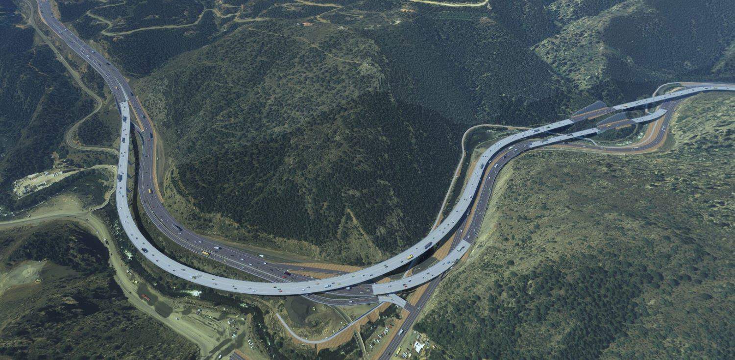
The Colorado Department of Transportation (CDOT) is working to improve travel time, enhance safety and upgrade an aging 8-mile section of Interstate 70 through the Rocky Mountains. Located near Floyd Hill outside of Denver, the stretch of roadway – which leads to major ski resorts like Vail and Breckenridge – is notorious for heavy congestion and narrow lanes. The CDOT project involves widening and redesigning the stretch of interstate, replacing six old bridges, and upgrading interchanges and intersections along the route. CDOT is also building two wildlife crossings under bridge spans to reconnect natural habitats that were disrupted by the road.
U.S. Transportation Secretary Pete Buttigieg, who visited the site in February, said the improvements will reduce congestion, increase safety and improve travel options, But it’s easier said than done: CDOT teams are working within site constraints, challenging topography, and the need to minimize the impact on environmentally sensitive areas and existing roadways.
Together with lead designer AtkinsRéalis, CDOT engineers are using infrastructure digital twins, 3D models of the road section and other solutions developed by Bentley. These solutions allow the team to keep the digital twins up to date with real-world data, share designs with stakeholders and explain plans to the community in an intuitive way that’s easy to understand. In addition to reducing traffic congestion and creating new wildlife passageways, the project will also improve existing pedestrian and bike trails when completed in 2028. You can watch a video of the latest project rendering.
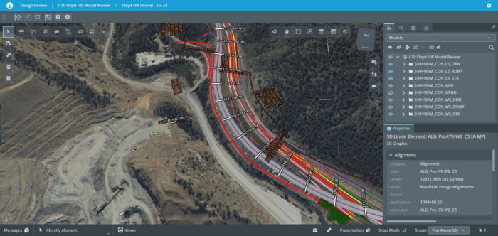 AtkinsRéalis created digital twins to communicate design intent with stakeholders, integrate with the community, and efficiently update models for their work on I-70 in Colorado. Courtesy of AtkinsRéalis.
2. Building Bridges in New York City
The New York State Department of Transportation (NYSDOT) is replacing one of the key commuter arteries into Manhattan, the 138th Street Bridge in the Bronx just south of Yankee Stadium. Originally built in 1938, the bridge has seen a swell of traffic demands and experienced clearance issues over the years.
About 150,000 vehicles cross the structure every day, so NYSDOT can’t just shut down the bridge, block off the area and get to work. Another major issue: Underneath the bridge is another critical road, the Major Deegan Expressway, and a concealed web of utility assets that supply gas, power and water to residents. Without careful planning and design workarounds, the bridge replacement could disrupt travel across two roads and the functioning of vital city services.
Project teams used Bentley software to develop a digital twin of the entire bridge structure and surrounding area. In fact, they gathered so much detail, they were able to use the digital twin as the legal contract document. Being able to visualize the site in 3D helped the teams better understand the project, and allows them to quickly experiment with different design options to accelerate construction and minimize the impact to traffic and pedestrians.
The digital twin has also helped improve and smooth communication. More than 180 reviewers across 15 agencies had access to the model to highlight and comment on potential design challenges without having to review over 200 traditional “plansheets,” a process vital for gaining project approvals. The digital twin strengthened public outreach, helping everyone understand the project’s developments and planned road closures.
The detail and insights provided by the digital twin ultimately helped the team secure a winning contract bid for the project that came in 15% below the anticipated cost. The digital twin also clears the way for more informed decisions during the entire lifecycle of the project. Teams are now constructing the new bridge in four phases, all of which leave room for traffic and pedestrians to continue their regular commutes.
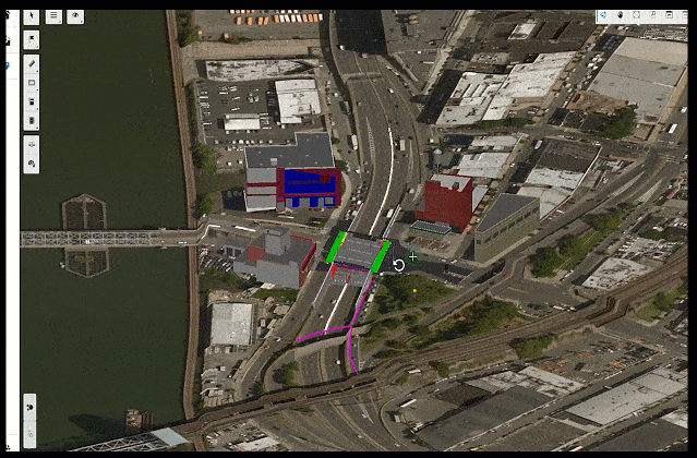 New York State’s Department of Transportation set a new standard for using a digital twin as the primary contract document. Video courtesy of NYSDOT.
3. Laser focus in iowa
Perry, Iowa, now has a digital twin. The project started when city officials wanted to meet requirements in the Americans with Disabilities Act (ADA) to ensure that all residents could easily traverse the streets. “Our job at the City of Perry is to improve people’s quality of life,” said Sven Peterson, Perry’s city administrator. “We want to make Perry a better and easier place to live.”
They used a mobile LiDAR unit – a laser-based remote sensing technology – to capture images of street curbs for ADA compliance. During the work, the teams realized they could also gather data about the city’s other assets and build a municipal digital twin, which could inform new development, and help with disaster preparedness, flood control and emergency vehicle dispatch. “A neighboring town had a tornado, which did a lot of damage to one of their historic buildings,” Peterson said. “They had to try to rebuild it just by using old photos. If one of our buildings gets damaged, we [now] have digital replicas of them.”
The city captured 375,788 images of streets, sidewalks, buildings, signs, trees and other assets. Using Bentley’s software, they turned the 4.1 terabytes of information into a detailed 3D reality mesh of the town. Perry’s downtown is part of the National Register of Historic Places, and the digital twin could help the city obtain tax incentives by helping it meet the register’s standards. It could also help the city enact its Comprehensive Plan 2030 – a package of infrastructure initiatives. “Our council and mayor are great at seeing the bigger picture and the direction we’re headed,” Peterson said.
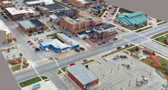 Foth processed 4.1 terabytes of information, into a detailed 3D reality mesh of the town. Courtesy of Foth.
Chris Noon is a freelance business reporter and foreign correspondent. He writes about energy, sustainability, and industry.
