There is something exciting about starting a new water project. It can feel like an opportunity to make significant improvements that could ultimately better the lives of the people it will serve.
Analyzing the historical data can feel like you are part of an archeological dig. You explore and decode what previous engineers considered, assumed, and documented. You uncover the past and it guides you on how best to enhance and optimize the infrastructure to better align with current needs.
Every project is unique. They have different requirements, existing conditions, challenges, and scenarios. The art of engineering is to be able to provide creative solutions that best serve those unique requirements. That includes identifying the right methods and optimal technologies that support the business workflow most efficiently ̶ and at the lowest cost.
In this article, you will be introduced to three key tools that will help you dive into a new project with the skills needed to execute with confidence. These OpenFlows SewerGEMS tools will take you from idea to design to collaboration with your colleagues and clients, with ease.
Most of us have heard of the acronym GIGO – garbage in, garbage out. It implies that the quality of output is determined by the quality of the input. If the quality of the data you put into a model is low, then the quality of the information produced will also be low. That’s what these three critical tools are all about. The Model Builder, Design Constraints, and TRex tools, in SewerGEMS, will enable you to upload the data within a few clicks and alert you if something is not correct. You will also be able to view it in different tabulates such as Flex Table, Network profiles, and ability to filter the network layout by color coding.
Model Builder
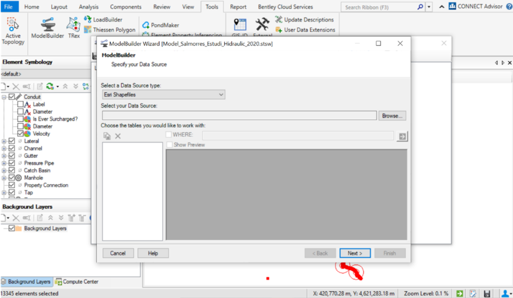
Model Builder is a powerful tool that allows you to smoothly import different data sources such as CAD files, Esri Shapefiles, HTML Import, Oracle, Excel, and more. Using a tool that works with so many file formats gives you the ability to instantly read different types of data, saving you from time spent converting files. You will find the Model Builder tool within the Tools icon as shown in the images.

Design Constraints
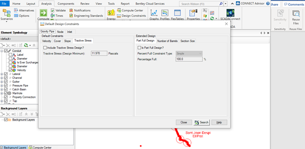
By using Design Constraints in SewerGEMS you are able to set the communication tone between you and your model. This feature lets you set clear rules such as maximum/minimum velocity, maximum/ minimum depth, and maximum/minimum slopes. You can also set the pipe to match the invert or crown level depending on your way of modeling and the nature of your network. You can ask the software to consider drop structure to minimize considering higher covers which provides cost savings in the project. Design Constraints has a customized tool for Storm Water Network that allows you to set the constraints to encounter for maximum gutter spread and depth as per design requirements to make sure that your design is the most efficient. You will find Design Constraints under the Analysis icon as per the picture below.

TRex
TRex is a feature that can be used to load elevation data into the model (nodes) from a variety of file types – including both vector and raster files. To use raster files as the data source, the ArcGIS platform must be used which is compatible with SewerGEMS. With a vector data source, it is possible to use any platform. Vector data must consist of either points with an elevation or contours with an elevation.
It is important to understand the resolution, projection, datum, units, and accuracy of any source file that will be used to load elevation data for nodes.
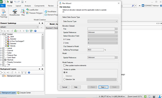
The elevation data source and features to which elevations will be assigned are specified in the File Selection dialog of the TRex wizard. Below are the valid elevation data sources that can be imported into the model:
- Vector files such as DXF and SHP files
- LandXML files
- InRoads .dtm (Microstation platform only)
- Geopack .tin (32-bit version only)
- Bentley MX .fil
- Bentley .dgn (Microstation platform only)
You can find the TRex Wizard in the tools icon in the SewerGEMS interface as shown in the picture below.

If you have questions or would like clarification on any of the tools outlined above, please feel free to reach out to the author of this article, Rua Suleiman, EMEA Product Consultant. [email protected]

