As urban populations surge and transportation systems strain under increasing demand, cities around the world are grappling with mounting challenges in mobility planning. Mobility Simulation is becoming essential as agencies strive to address issues, such as congestion, safety concerns, and environmental impact.
The need for equitable access is pushing agencies to rethink traditional approaches which often fall short in managing the complexity of today’s multimodal networks. Planners are now under pressure to deliver data-driven solutions that are ready for the future.
What is Mobility Simulation?
Imagine a city where traffic jams are a thing of the past, and public transportation runs seamlessly. Mobility simulation is a process that helps cities and transportation agencies address challenges in mobility planning by letting you model, analyze, and optimize transportation systems to create more efficient and sustainable urban environments. It involves the use of advanced tools and software to simulate various scenarios.
Imagine a virtual model of a city’s transportation network, including roads, buses, trains, and even pedestrian pathways. This model allows planners to evaluate different scenarios, such as adding a new bus route or closing certain roads for construction. By leveraging mobility simulation, cities can create more efficient, safe, and sustainable transportation systems for their residents.
A Holistic Mobility Simulation Portfolio
Bentley is helping organizations meet these challenges with a unified approach to mobility simulation. By providing software for multimodal planning, pedestrian modeling, and advanced analytics, Bentley empowers infrastructure owners, agencies, transportation professionals and consultants to model, analyze, and optimize mobility systems at every scale—achieving enhanced safety, improving efficiency and sustainable results.
Open Paths to Better Mobility
Bentley OpenPaths is Bentley’s next-generation solution for multimodal transport modeling. It brings tools like CUBE, EMME, DYNAMEQ, and AGENT into a single licensed product. It includes:
- Integrated Demand and Network Modeling for a complete view of mobility.
- Activity-Based and Advanced Travel Demand Modeling to address modern planning challenges.
- Automated Calibration using big data to reduce manual effort.
- User-Friendly Interfaces that make model updates faster and more accessible.
Together, these tools help users forecast demand, test infrastructure investments, and optimize transportation systems across cities, corridors, and regions. Bentley OpenPaths is available in two tiers, Advanced and Ultimate, so users can choose the right fit for their strategic and operational needs.
Case Study
The City of Edmonton utilized Bentley OpenPaths to develop a digital replica to model Edmonton’s roads and highways. By leveraging the capabilities of Bentley OpenPaths, The City of Edmonton was able to create detailed multimodal transport models that provided an evidence-based approach to inform their transport planning decisions. The City of Edmonton’s use of Bentley OpenPaths led to significant timeline and cost savings, improved traffic flow, reduced congestion, and enhanced overall mobility for its residents. Learn more here ❯
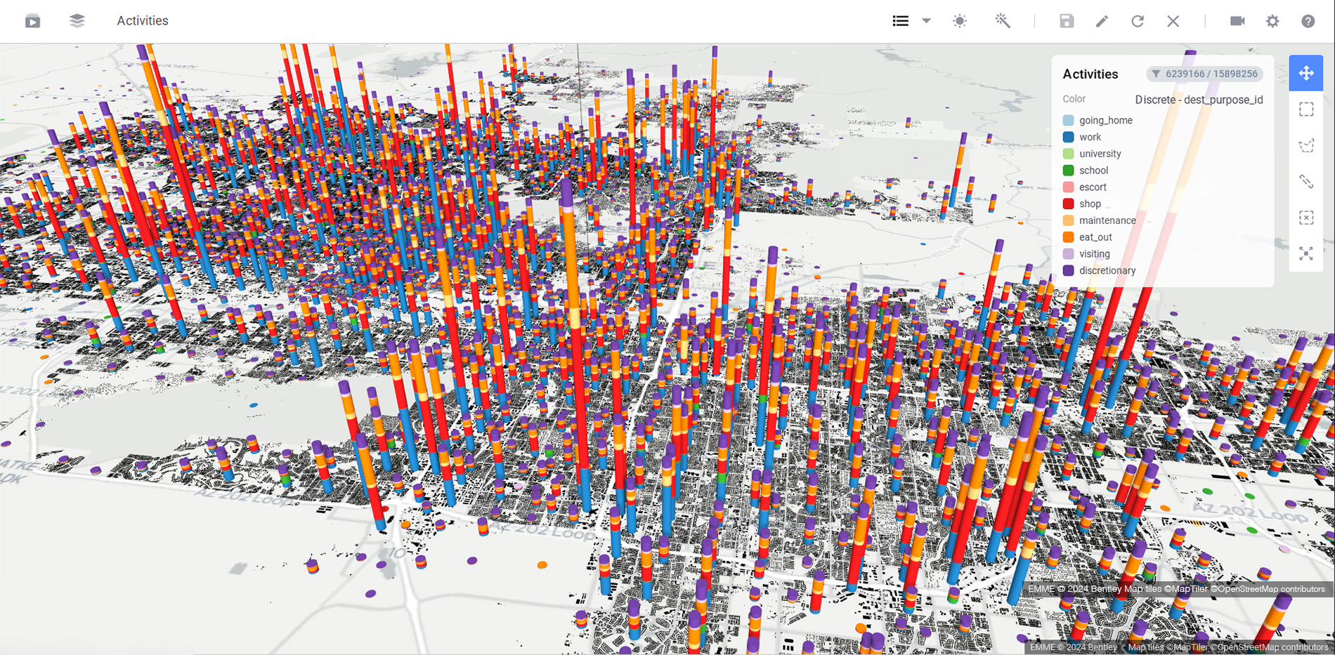
 Bentley OpenPaths DYNAMEQ supports key decision support for operational traffic planning in lock-step with the city’s capital planning project requirements.
Pedestrian Simulation at Its Best
Accurately modeling human behavior in diverse environments requires sophisticated algorithms and high-quality data. Factors such as crowd dynamics, individual decision-making, and environmental influences must be considered to ensure realistic outcomes. Moreover, integrating pedestrian flows with other modes of transport adds complexity to the simulation process. Addressing these challenges is crucial for delivering reliable insights that inform urban planning and infrastructure design.
LEGION is Bentley’s pedestrian modeling software, used by transit agencies, rail operators, and architects to simulate the movement of people in stations, terminals, and public spaces. It enhances safety, comfort, and operational efficiency by allowing planners to evaluate and refine design alternatives in a virtual environment before construction ever begins.
Case Study
LEGION was instrumental in optimizing pedestrian flow and safety during the expansion of Gare du Nord railway station in Paris. By simulating various design alternatives and operational scenarios, the project team was able to identify and mitigate potential congestion points, ensuring a smooth and efficient movement of people within the station. This proactive approach not only enhanced the passenger experience but also improved overall safety and operational efficiency. Learn more here ❯
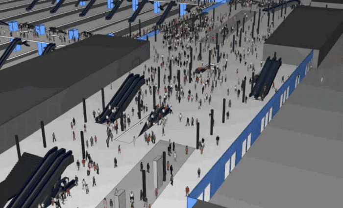 LEGION – The passenger simulation informed the station’s final configuration, ensuring smooth operations during peak volume.
Big Data for Better Decisions
Leveraging mobility data analytics comes with its own set of challenges. Data privacy and security concerns must be addressed when managing sensitive location information. Ensuring data accuracy and consistency across various sources is critical for meaningful analysis. The sheer volume and variety of mobility data can overwhelm traditional processing tools, necessitating advanced analytics platforms and skilled personnel to extract actionable insights. Overcoming these hurdles is essential to fully realize the potential of data-driven decision-making in transportation planning.
Bentley OpenPaths Patterns is a web-based mobility data and analytics application that gives users instant access to travel behavior insights across the United States. It provides origin-destination data, hourly traffic volumes, and tools like:
- Select-link analysis to understand how specific road segments or transit links are used within a network.
- Desire lines which visualize the most direct paths people take between origins and destinations.
These insights support modeling workflows and planning decisions with clarity and confidence. Whether you are calibrating a travel demand model or exploring new transit corridors, Bentley OpenPaths Patterns helps you understand how, when, and where people move.
Case Study
The Baltimore Metropolitan Council (BMC) completed an Origin Destination (OD) flow analysis on the Francis Scott Key Bridge using ZIP Codes. By leveraging the capabilities of Bentley OpenPaths Patterns, BMC was able to respond to policy board questions regarding the number, location, and travel impacts. The software’s flexibility allowed BMC to upload geographic data (ZIP Codes), identify a gate (Key Bridge), and capture and display OD flows. This proactive approach provided valuable insights into travel patterns, enabling BMC to make informed decisions to improve regional mobility and infrastructure planning.
Ready to transform how you plan, model, and optimize mobility?
In a world where mobility challenges are growing more complex, Bentley’s tools offer clarity, confidence, and control. Discover how Bentley’s mobility simulation tools—Bentley OpenPaths, LEGION, and Bentley OpenPaths Patterns—can help you make faster, smarter transportation decisions.
Visit Bentley’s Mobility Simulation Software page to learn more or schedule a personalized demo today.