Optimize CAD Workflows with AI Automation and Geospatial Context from MicroStation 2025
Understanding Design Challenges
It is crucial to design and build infrastructure that will provide vital clean drinking water, withstand natural disasters, and allow communities and families to stay connected. This work carries immense responsibility, affecting the well-being of people today and in the future.
Vital utilities such as providing water, electricity, and sewage systems need to address aging infrastructure, modernization, and community needs. If aging infrastructure isn’t addressed, communities may face frequent outages, water contamination, and sewage overflows. Transportation networks must integrate multiple modes of transport, accommodate growth, and ensure accessibility. Without integration and accessibility, people might experience longer commutes, limited mobility, and increased stress. City infrastructure incorporates the complexities of urban form, connectivity, and resilience. Failing to incorporate these elements can result in disconnected neighborhoods, vulnerability to disasters, and inefficient services.
Infrastructure professionals navigate numerous problems and challenges throughout the design and project lifecycle. Frequently, they face limitations when using computer-aided design (CAD) software in their workflows.
This blog post explores how advancements in AI automation and geospatial context can address these challenges. Specifically, MicroStation 2025 helps to solve design challenges faster and with more confidence.
Key MicroStation 2025 capabilities:
- Python coding language for creation of custom tools and automations.
- AI-powered Python Assistant for even easier creation of custom tools and automations.
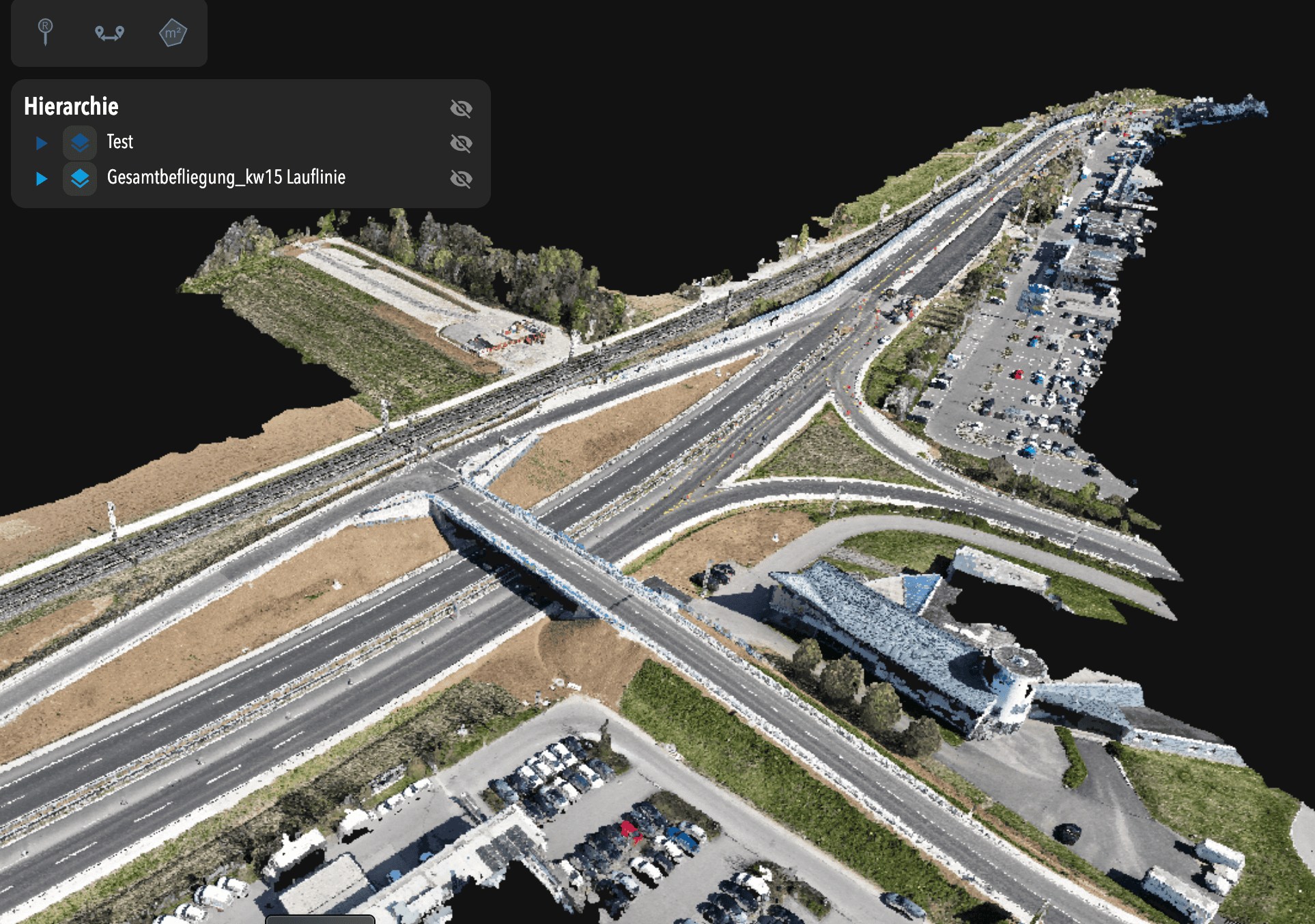
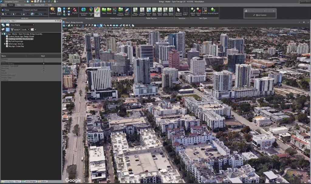
- 3D Tiles and Google Photorealistic 3D Tiles support to visualize your designs.
- Google Maps support for infrastructure designs.
- Geospatial context functionality in MicroStation API for geospatial workflows.
- Esri file geodatabase support to connect the design environment with a geographic information system (GIS).
Designing with Automation
CAD software provides powerful design capabilities, but design freedom is often limited by the constraints of the software itself. For example, current CAD tools often overwhelm users with a high volume of time-consuming, repetitive tasks. Users and third-party developers often have unique requirements that extend beyond the core features of CAD software. It necessitates the ability to create custom tools and automations, which can improve efficiency, but doing so often requires interacting with a software’s API—a daunting task for those without programming experience with scripting languages.
It’s important to complete more design tasks within the primary CAD environment. To assist users no matter their level of programming skill, MicroStation 2025 extends its customization and AI automation functionality through the integration of Python. Its readability and simplicity make it a powerful tool for automating mundane tasks. Python scripting, which involves creating small programs to automate tasks or perform specific functions, is not full-on software development. It focuses on quick, effective solutions to everyday problems. MicroStation 2025’s Python Assistant makes it much easier to create Python scripts and CAD automation. Even those new to programming can use it to create partial and complete Python scripts.
Python Assistant is a generative AI assistant developed by Bentley, based on pre-trained large language models. This assistant, which uses artificial intelligence and machine learning, is designed to help with a wide range of tasks by simplifying complex coding concepts and automating mundane tasks. In short, Python Assistant makes software development more accessible to non-experts.
MicroStation’s support of Python and Python Assistant delivers significant value. It helps you create anything you need within the software while removing blockers and increasing the number of tasks users can complete in MicroStation. Python uses a simple syntax comparable to English and has widespread support. Combining Python with Python Assistant maximizes adoptability and improves productivity. It empowers users to tailor tools to their specific needs, automate tasks, and finish tasks faster, helping them win more work. MicroStation users can leverage Python Assistant to discover new uses for the technology and create personalized, relevant solutions that help improve client engagement.
With Python Assistant, more users can create automations within MicroStation. This is great for repetitive tasks and limited customization. A broader range of infrastructure professionals such as CAD managers, designers, modelers, and drafters can spend more time on higher-value design work. They have more time to spend on planning and conceptualization. Identifying design constraints and opportunities earlier in the process. This allows for creative problem-solving and can ensure infrastructure projects remain within budget while complying with regulation.
Unlike other products that rely on third-party Python APIs, which can carry the risk of lack of support or discontinuation, MicroStation provides an in-house Python solution. It is fully developed, supported, and updated by Bentley software engineers, Python developers, geospatial analysts, and CAD and BIM specialists. They continually refine Python Assistant to provide higher-quality responses compared to competitors’ assistants, which learn from open-source data but aren’t tuned to the MicroStation Python environment. Bentley prioritizes safeguarding user data and complying with data protection regulations. Users have full control over how their data is used in training AI models.
MicroStation’s Python support includes a Scripting Interface and the AI Python Assistant. Automate tasks like batch processing, report generation, and modifying design elements. Users can create custom tools tailored to specific project needs. Python’s extensive libraries facilitate interoperability with other software and systems, enhancing workflow efficiency. Python Assistant include natural language queries, contextual awareness, and supports multiple languages. It can do code documentation generation and test generation.
“This is a good start to motivate users to explore automation or create macros.”
– MicroStation 2025 early access user
Designing with Geospatial Context
Engineers and architects like to see their designs within real-world locations, as it can provide invaluable insights for decision-making. Some of the benefits of including detailed geospatial context in projects include:
- Analyzing geographic data and environmental factors
- Ensuring connectivity with existing infrastructure
- Assessing the potential environmental impact
- Evaluating risk assessment from hazards such as flood zones
- Planning efficient resource management and analyzing community impact
However, establishing geospatial context can be a significant problem, as data often comes from disparate sources, making consolidation difficult. Infrastructure projects can involve working with large datasets, which can present difficulties with incorporating external geospatial data sources and poor cross-platform compatibility .
MicroStation 2025 provides enhanced geospatial context capabilities so professionals can address these challenges and make geospatial information accessible to everyone. The application’s geospatial context enhancements include:
- Support for 3D Tiles: MicroStation 2025 supports 3D Tiles, an open standard for performantly streaming massive, heterogeneous 3D geospatial datasets. This new capability enables users to bring in reality models from iTwin Reality Management in 3D Tiles and directly display Google Photorealistic 3D Tiles within MicroStation, providing accurate real-world context for designs. Thanks to Bentley’s partnership with Google and recent acquisition of Cesium, the driving force behind 3D Tiles, MicroStation users are well-positioned for continued innovation and a leading-edge experience.
- Google Maps support: MicroStation 2025 supports Google Maps as a background map. This replaces Bing Maps. Users now experience superior image quality and accuracy. They can access more recent data for their 2D background map context. This Bentley and Google collaboration brings powerful geospatial context and capabilities to users. Google Maps is easy to use within the existing UI/UX. Users can display aerial imagery and maps together with their project data.
“A much-improved feature. I prefer Google Maps over Bing and there seem to have been some performance improvements too.”
– MicroStation 2025 early access user
- Geospatial context functionality added to MicroStation’s API: This addition includes the MicroStation Python API, directly addressing the challenge of using scripting for geospatial workflows. MicroStation users can write Python scripts to work with geospatial context. Scripts automate tasks, save time, reduce errors, and improve the visualization of designs.
- Esri file geodatabase support: This support was introduced in the MicroStation 2024.2 release. It increases interoperability between the design environment and geographic information system (GIS). MicroStation users can share their design into the Esri format and import data from Esri, a leader in GIS software. Its widely used file geodatabase format stores various types of geographic and nonspatial data. Supporting it enhances interoperability and the ability to consolidate data from disparate sources. MicroStation users can share their design into the Esri format and import data from Esri, a leader in GIS software. Its widely used file geodatabase format stores various types of geographic and nonspatial data. Supporting it enhances interoperability and the ability to consolidate data from disparate sources.
- Vertical datum improvements: Geospatial coordinate systems have been improved by adding support for more vertical datums. A vertical datum is a reference surface used to measure elevations or altitudes of Earth-bound features. These features include terrain, water levels, and built structures. It is a baseline for determining the height of various points relative to a defined zero elevation. Using the appropriate vertical datum is essential for accurate elevation calculation and precision. It also supports better Esri features, GIS features, and digital twin capabilities.
These enhancements improve how external geospatial data is integrated and enable cross-platform compatibility by supporting industry standard formats like 3D Tiles and Esri file geodatabases. 3D Tiles performantly stream massive, heterogeneous 3D datasets. The addition of geospatial context to the Python API helps users leverage scripting for geospatial tasks, which can ease the learning curve for integrating geospatial analysis into their workflows. CAD designers, urban planners, civil engineers, architects, and developers integrate geospatial context into their designs, and are the ones most likely to benefit from these new geospatial features.
MicroStation’s core features also contribute to tackling broader data challenges. It has interoperability with many industry standard formats for graphics and data consolidation and exchange. The software has the ability to work with huge data sets efficiently. Infrastructure professionals sometimes face collaboration challenges, such as project files being unavailable to stakeholders. With MicroStation, teams can easily share data for effective collaboration.
Looking Ahead
Ready to break free from repetitive tasks and boost productivity? Learn how MicroStation 2025’s Python scripting and the AI-powered Python Assistant make automation accessible for everyone, allowing you to spend less time on mundane work and more time on value-adding design.
Integrate real-world geospatial context into your designs and stop struggling with large geospatial datasets. Discover how MicroStation 2025’s advanced geospatial capabilities, including support for 3D Tiles and Google Maps, enable you to design with accurate context and make informed decisions for efficient and successful projects.