In the ever-evolving world of road infrastructure design, excellence extends far beyond pavement quality and geometric precision. A crucial, often underestimated factor is efficient drainage management. OpenFlows CivilStorm, included in Civil WorkSuite, is transforming how engineers approach road design with cutting-edge hydraulic and hydrological modeling capabilities. This comprehensive solution addresses the complex challenges of modern road design, ensuring safety, durability, and sustainability in an era of climate change and increasing urbanization.
Comprehensive hydraulic and hydrological modeling
OpenFlows CivilStorm offers a complete approach to analyzing complex drainage systems, providing engineers with the tools to create robust and resilient road infrastructure:
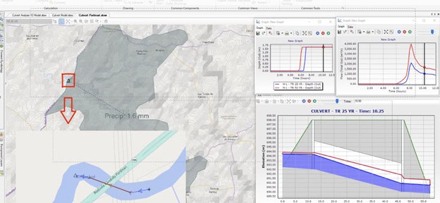
- 1D/2D analysis: Enables one-dimensional and two-dimensional hydraulic modeling to accurately simulate surface flooding. This dual approach allows engineers to model both pipe networks and overland flow, providing a comprehensive understanding of how water moves through and around road infrastructure.
- Watershed modeling: Simulates watershed behavior, crucial for understanding runoff patterns affecting the road. By accurately modeling the entire catchment area, engineers can anticipate and mitigate potential flooding issues before they impact the road structure.
- Urban and rural drainage systems: Covers both urban and rural environments, adapting to diverse road design contexts. This versatility ensures that OpenFlows CivilStorm can be applied to a wide range of projects from busy city streets to remote country roads.
Advanced technical features
Complex scenario analysis
- Extreme event simulation: Models intense storms and floods, allowing for climate-resilient infrastructure design. This feature is particularly crucial in the face of increasing climate variability, enabling engineers to design roads that can withstand more frequent and severe weather events.
- Critical storm analysis: Evaluates system behavior under different rain intensities and durations to identify the most unfavorable conditions. This helps in designing drainage systems that can handle a wide range of storm events, ensuring road safety under various weather conditions.
- Continuous simulation: Allows for long-term analysis of drainage system performance, providing insights into how the infrastructure will behave over its entire lifecycle.
Optimized hydraulic design
- Automatic sizing: Determines the most cost-effective pipe sizes and invert elevations, optimizing drainage system design. This feature not only improves efficiency but also helps in reducing project costs without compromising on performance.
- Complex hydraulic structure modeling: Simulates the behavior of weirs, orifices, culverts, and outfall structures under various tailwater conditions. This comprehensive modeling ensures that all components of the drainage system work together effectively.
- New roadway weir type: Models road overflow using the FHWA HDS-5 method, crucial for evaluating hydraulic behavior at water crossings. This feature is particularly important for designing safe and effective stream crossings and floodplain encroachments.
- Pump station design: Incorporates advanced pump modeling capabilities, allowing for the design of efficient pump stations where gravity drainage is not feasible.
Water quality analysis
- Water quality studies: Allows assessment of the environmental impact of road drainage on receiving water bodies. This feature helps engineers design systems that not only manage water quantity, but also protect water quality in surrounding ecosystems.
- Pollutant load analysis: Simulates the transport and treatment of various pollutants, helping to design systems that meet environmental regulations and minimize ecological impact.
Efficient integration and workflow
- Compatibility with OpenRoads and OpenSite: Seamlessly integrates with these Bentley applications, allowing hydraulic analyses to be incorporated directly into 3D road models. This integration streamlines the design process, reducing errors and improving collaboration between different engineering disciplines.
- Versatile import/export: Supports standard formats such as GIS, CAD, databases, and spreadsheets, facilitating interoperability with other software. This flexibility allows for easy data exchange and collaboration across different platforms and teams.
- Scenario management: Allows configuration, evaluation, and comparison of an unlimited number of scenarios within a single file, facilitating decision-making. Engineers can easily test different design options and quickly identify the most effective solutions.
- Automated design checks: Incorporates built-in design standards and checks, ensuring that designs meet regulatory requirements and industry best practices.
Innovations in sustainable design
- Low impact development (LID) modeling: Includes new options, such as the “rooftop disconnection” control type and enhanced soil fields for porous pavements, enabling more sustainable designs. These features allow engineers to incorporate green infrastructure solutions that mimic natural hydrological processes.
- Green infrastructure analysis: Evaluates the effectiveness of nature-based solutions for stormwater management, such as rain gardens, bioswales, and permeable pavements. This capability supports the growing trend towards more environmentally friendly and resilient road designs.
- Climate change adaptation: Allows for the incorporation of climate change scenarios into design considerations, ensuring that road infrastructure is prepared for future environmental conditions.
Advanced visualization and reporting
- 3D visualization: Three-dimensional visualization capabilities allow better communication of designs to non-technical stakeholders. This feature is invaluable for public presentations and client meetings, helping to convey complex engineering concepts in an accessible manner.
- Dynamic result presentation: Offers animated visualizations of simulation results, providing intuitive insights into system behavior under different conditions.
- Automatic report generation: Produces detailed project documentation, including drainage structure sheets and quantity summaries that save time and reduce errors. This feature streamlines the documentation process, ensuring that all necessary information is accurately captured and presented.
- Customizable dashboards: Allows users to create personalized dashboards for quick access to key project information and performance indicators.
The adoption of OpenFlows CivilStorm in road projects represents a qualitative leap in the design process. By combining advanced hydraulic analysis with optimization and visualization tools, engineers can create safer, more durable, and sustainable infrastructures. In a context of increasingly extreme climate events and more demanding infrastructure requirements, tools like OpenFlows CivilStorm become indispensable for professionals committed to excellence in road engineering.
As we look to the future of road design, the integration of advanced hydraulic modeling with traditional road engineering practices will be key to creating resilient, efficient, and environmentally responsible infrastructure. OpenFlows CivilStorm stands at the forefront of this integration, offering a comprehensive solution that addresses the complex challenges of modern road design.
Read more of Tom’s blogs here, and you can contact him at [email protected].
Want to learn more from our resident water and wastewater expert? Join the Dr. Tom Walski Newsletter today!