We have made significant improvements to OpenFlows. The introduction of the new 2D solver allows for a more comprehensive analysis of urban flooding models, integrating both 1D and 2D analyses.
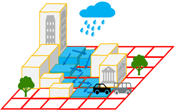
The 2D model can report results such as surface flow, surface velocity, and water depth. It also can couple 1D/2D urban flooding models, including 2D flow from overtopping structures and 2D flow captured by structures, as well as rainfall runoff.
Here are the advantages of 2D simulations, and when should you use a 1D or a 2D simulation, now that both are available to you.
Some background for the 2D solver
In the past, you could perform quasi-2D modeling within OpenFlows SewerGEMS or OpenFlows CivilStorm using a network of 1D channels and/or ponds. The downstream trace query can be used to show where overflows would occur on a terrain model. Once you know the locations, you can set up channels along the flow paths to analyze the flows.
Another option was to perform a full 2D simulation by integrating the 1D piped network modeling in OpenFlows SewerGEMS or OpenFlows CivilStorm with the 1D (river reaches) and 2D (surface) domains of OpenFlows FLOOD.
Now, you can easily use a full 2D simulation in a single platform with our new 2D solver.
Transitioning from 1D to 2D hydraulic modeling can be challenging at first, but with the right understanding and capabilities, it can be a smooth process.
What is a 2D model?
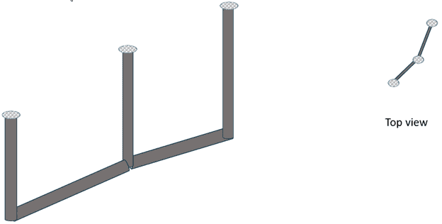
A 1D model involves laying out cross sections along the river or channel.
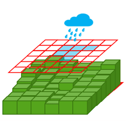
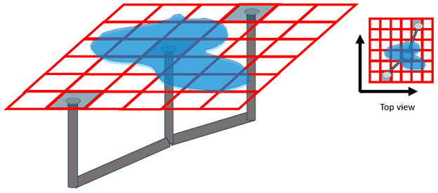
The 2D hydraulic model simply lays a mesh over the terrain data. The 2D hydraulic computations and the terrain representation determine where the water goes.
Coupling 1D Elements with 2D
Coupling the 1D model to the 2D model for surface flow provides the following benefits when compared to the traditional 1D approach:
- Fewer modeling assumptions and less user judgment yield results that are more representative of actual conditions.
- Enhanced communication with stakeholders through engaging graphics, videos of flow paths, and georeferenced results.
- Accurate representation for complex conditions, including wide floodplains, sinuous channels, multiple channels, bends and confluences, roadways and overtoppings, and other conditions.
 1D vs. 2D
The question of deciding between 1D versus 2D models is much tougher than deciding between steady or unsteady flow. There are applications that produce better results with 2D modeling than 1D modeling, and there are also situations where 1D modeling can produce results that are just as good or better than 2D modeling with less computational effort.
However, many situations fall into a gray area, with both positive and negative aspects of both methodologies for specific applications. I believe that with the right applications, the combined 1D/2D models will play an important role in analyzing, designing, and operating resilient and sustainable infrastructure.
When to use a 1D model
1D modeling can potentially produce results as good as 2D modeling with less effort (such as model development, calibration, and computational time) in situations that include:
- Conduits/pipes/channels that have unidirectional flow.
- Systems (channels, conduits, and pipes) with numerous obstacles, such as bridge and culvert crossings, weirs, dams and other gated structures, levees, and pump stations.
- Limited access to good terrain data. Although 1D and 2D models depend on terrain data, you can more easily remove anomalies from 1D cross-sections.
- Limited time, as 2D models can take longer to run. If your client needs a model quickly, it may be better to prepare a 1D model – especially if you have yet to create a 2D model.
When to use a 2D model
Some topographic and hydraulic features make 1D modeling difficult. Some of these features include an undefined boundary between channels and overbanks, unclear flow directions, high-gradient flow in off-channel storage areas, a flow direction that changes significantly with different stages, and river bends. Therefore, you should try to use 2D modeling for situations that include:
- Urban areas.
- Wide floodplains.
- Areas where flow spreads and the path of the water is not completely known, such as in an alluvial fan.
- Overflow and flooding risk studies.
- Applications where it is very important to obtain detailed velocities for the hydraulics.
Before you start your first 2D model
Here are some key points to keep in mind before you start creating your 2D simulation:
- Terrain Data and 2D Flow Area: A 2D simulation requires digital terrain data and a 2D flow area. The user can designate the size and direction of the cells that comprise the 2D flow area.
- Hydraulic Structures and 1D Elements: OpenFlows allows the user to add hydraulic structures and 1D elements, such as storage areas, to a 2D model, enabling a more comprehensive and integrated analysis.
- Run Times: 2D models generally have much longer run times than 1D models due to their increased complexity and computational requirements. Therefore, it is important to factor the additional run times into your project timeline.
- Differences between 1D and 2D Models: While many engineers have experience with 1D modeling, 2D modeling brings key differences. For example, 2D models can capture lateral flow across the terrain, which is not possible with 1D models.
There are many resources available online that can guide you through the process of setting up a 2D model. I recommend checking Bentley’s official website or community forums for more detailed instructions and tutorials.
Remember, the goal of using 2D models is to provide a more accurate and detailed representation of the hydraulic system. While it may require more effort to set up compared to a 1D model, the additional insights gained can be invaluable for your hydraulic analysis.
https://bentleysystems.service-now.com/community?id=kb_article_view&sysparm_article=KB0013978
Water WorkSuite: Hydraulics Modeling Software | Bentley.
 1D vs. 2D
