Some engineering marvels were once highly controversial projects. As the Empire State Building grew above Manhattan during the Great Depression, many New Yorkers complained that the iconic Art Deco skyscraper was a waste of money. Throughout the 1990s, security-conscious Brits chafed about the Channel Tunnel, the undersea rail link between the U.K. and France. Even the Eiffel Tower upset Parisian salons, with the writer Guy de Maupassant eating his lunch on the wrought-iron tower to avoid looking at it.
The polarization over major engineering projects could soon be a relic of the past. Firms can now harness cutting-edge technology for their proposals to build stunning visualizations, which help to get communities onside before the laying of a single brick. Kansas City-based infrastructure giant HNTB is now using Cesium, the foundational open platform for creating powerful 3D geospatial applications that is now part of Bentley Systems, to render photorealistic landscapes around their highway, bridge, and interchange designs. HNTB teams are now publishing the sumptuous simulations online and garnering mountains of insightful feedback.
A Community Service
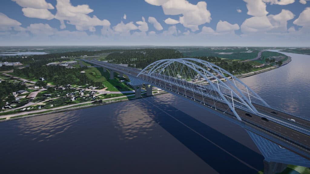
Dave Willard, who heads up HNTB’s Immersive Media Solutions unit, explains how interactive media and visualizations are raising the bar on public engagement. “It’s the power of showing, not telling,” Willard says while navigating through HNTB’s proposed interchanges for a bridge replacement project in Massachusetts. . “It’s important for stakeholders and property owners to understand what’s being planned to go through their neighborhood.”
HNTB’s interactive media visualizations are also user-friendly, which helps to keep public meetings enjoyable and efficient. When compared to more traditional methods, HNTB’s presenters don’t plod through 60 different project videos of interchange permutations, Willard explains. “They can just turn on and off options in real-time and even jump between projects within the same real time environment,” he says. “Presenters can gather public feedback during the meeting and develop a sense of the preferred option rising to the top.”
Using Cesium is also saving HNTB months at the drawing board. The company’s immersive visualization solutions team used to spend more than 1,000 hours modeling the surrounding context for major road projects, such as the I-69 Finish Line, . “Cesium has brought us down to the 200-to-300-hour mark for these kinds of projects,” says Willard.
Warning: Graphic Content
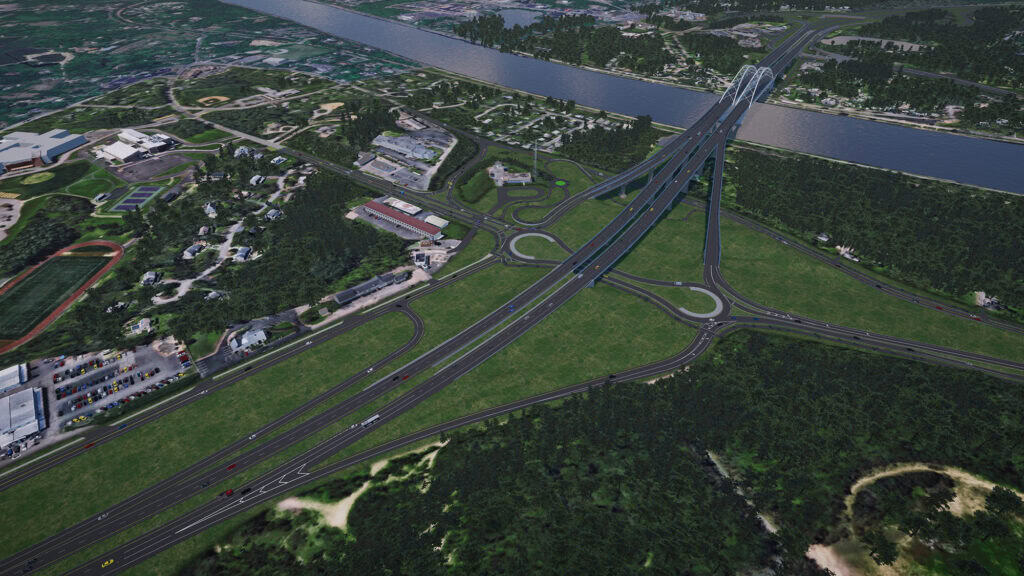
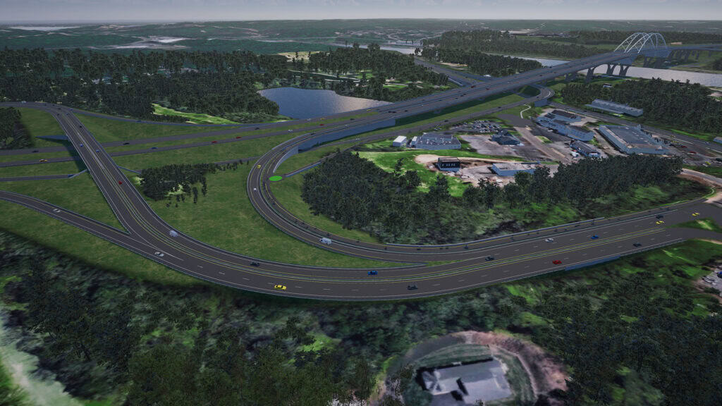
Detailed animations of major infrastructure projects are always vital to public engagement, but providing visual context has long been a chore for design engineers. In the past, HNTB’s designers used standard Building Information Modeling (BIM) software to build 3D replicas of their project. They would render their roads, bridges, and dams with millimeter precision by leveraging features such as parametric modeling, which automatically updates the whole model after adjustments.
Building their virtual concrete structures was the easy part. Designers then needed to simulate all the landscape, trees, and buildings in the vicinity. “We need to render at least a few hundred feet on all sides of the project just to have existing context that’s recognizable by the general public,” Willard says. This was a real slog: Designers used rendering engines to mold landscapes, 3D polygon modeling to fashion trees and buildings, and keyframe animation tools to breathe life into their creations. It could take them several weeks to model the stretches of landscape and rows of building alongside a 31-mile section of highway.
Afterward, they would have little to show for their toil. The end-products often looked a bit like the closed-world video games of the 1990s, says Willard. “The user had to fly over real quick and [they would only get] few seconds of detail,” he explains. “Then you’d have to ask the room, ‘That was the project, what do you think?’”
Context is King
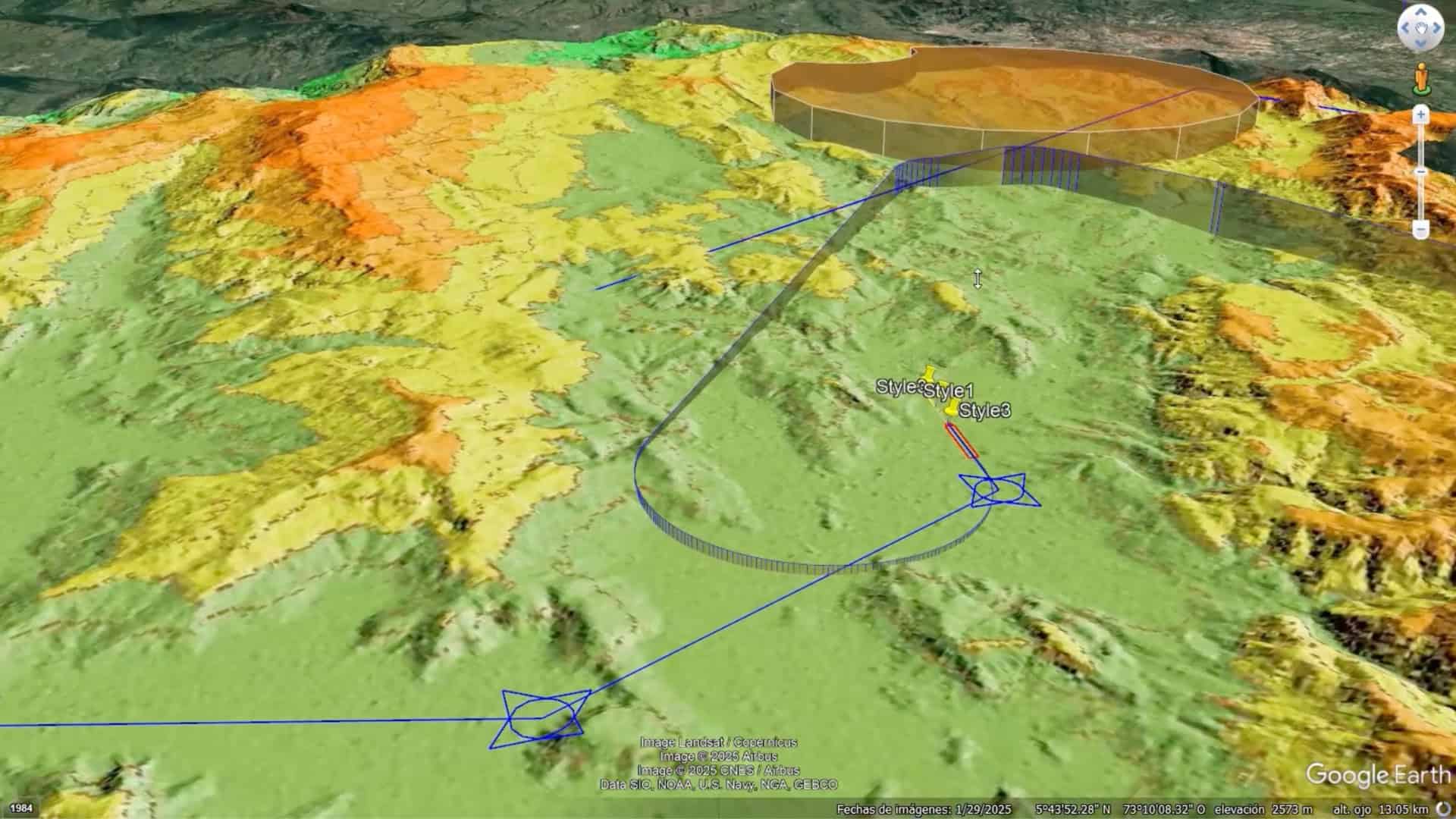
About 18 months ago, HNTB’s immersive media team began experimenting with Cesium for Unity. The free and open-source package combines the 3D geospatial capabilities of Cesium with the high-fidelity rendering power of Unity, one of the world’s most widely used game engines. (HNTB enhanced their setup with a commercial Cesium ion subscription, giving their teams access to cloud-based, high-resolution 3D content such as Google Photorealistic 3D tiles.)
It was a revelation. HNTB designers simply tapped in the GPS coordinates of their project location and began efficiently streaming massive, detailed 3D datasets of their vicinities. Bingo: Instant contexts, and liberated designers. “It’s removed the headache on our end, allowing us to focus purely on the design, rather than the area surrounding it,” Willard says.
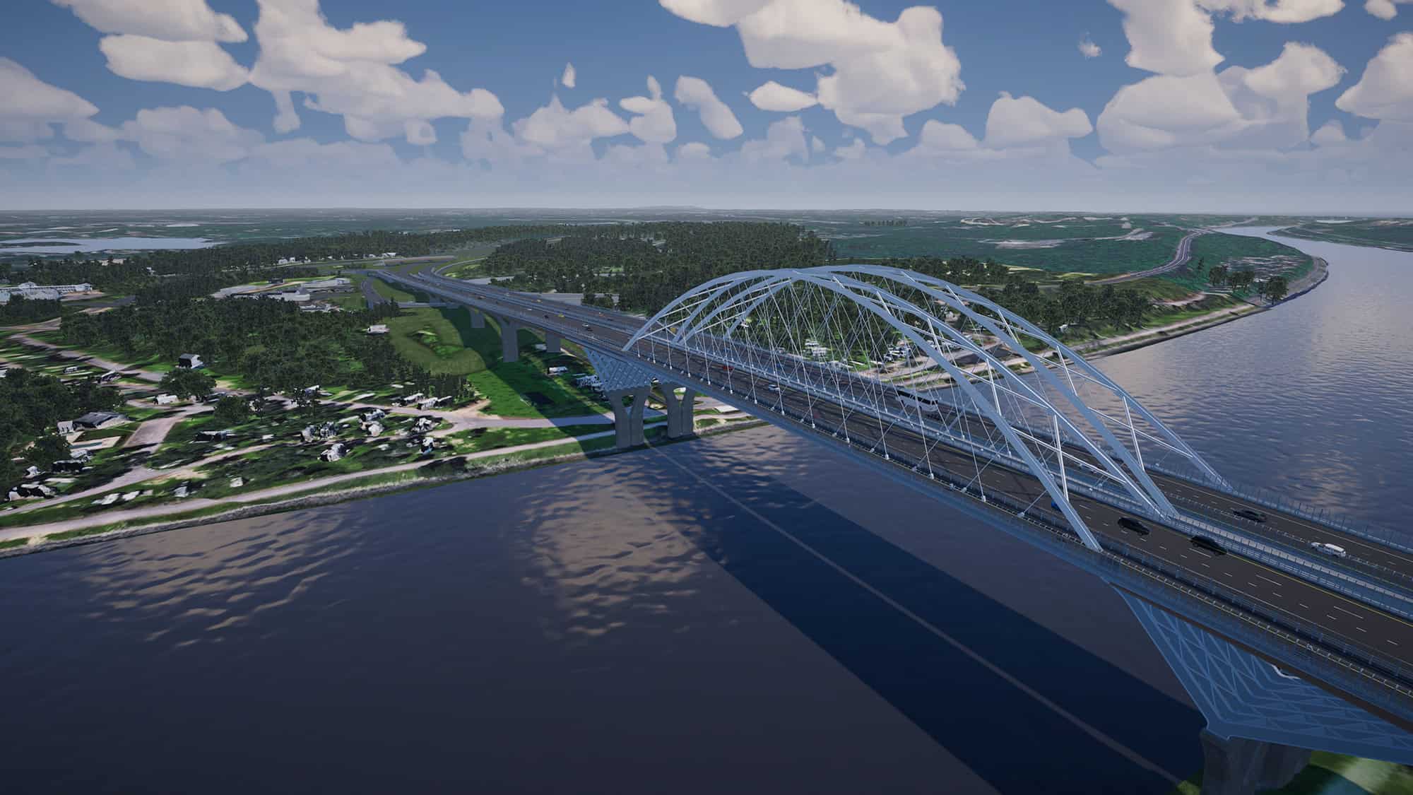
Visualizing HNTB’s roads, bridges, and dams is now a bit like the very best “open world” video games. “You can fly around wherever you want,” Willard says as he swoops over a stunning mock-up of a proposed design for a bridge linking barrier islands along the Gulf Coast of Texas. He hovers at 10,000 feet, like a kestrel, surveying the whole project, and then zooms into the individual strut of a bridge.
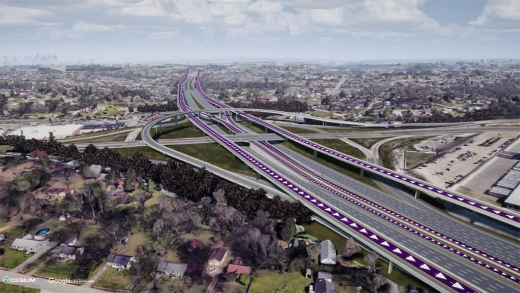
Cesium has turned HNTB into a master storyteller. Willard shows a proposal for a bridge replacement project where HNTB’s team built masking tools within Cesium so they could overlay potential designs on top of the old structure. The visuals allow viewers to easily compare the past with the future and scroll through proposals like outfits in a virtual wardrobe.
Good Spatial Awareness
Cesium also allows for the rendering of vertical space. Designers wove several geospatial layers into their Cesium visualization of the Texas bridge proposal, including data about underwater features. It allows users to see the locations of historic shipwrecks, which is vital information for the busy shipping lane. The teams are also modeling the curvature of the Earth, which is necessary data for long sections of highway. “Over 26 miles, you can get almost a 400-foot difference in elevation,” explains Adam Liss, HNTB’s senior immersive media specialist. “It’s important to be able to render this 2D-type information in a 3D context.”
Public feedback is literally embedded in the landscape. During a digital fly-by of a highway project in Tennessee, Willard shows how his team has developed a real-time 3D commenting feature that will allow stakeholders to provide feedback directly within their 3D interactive scenes. “As stakeholders drop comments within the scene, we begin to notice trends, or “hotspots” of comments that may help design teams when considering the need for design revisions in certain areas, or addressing issues of public concern,” he says.
The Road Ahead
The HNTB team feels like they’ve just scratched the surface of Cesium. Willard, who is hitting the industry conference circuit this summer, is excited about the continued integration of BIM data into Cesium visualizations. “As we transition away from manual modeling of existing context, technologies like Cesium will continue to make our workflows much faster,” says Willard. HNTB designers are also psyched about the prospect of tapping into additional Cesium capabilities to make their visualizations even more user friendly. “Right now, we deliver all this stuff via web stream on laptops,” Liss adds. “Imagine if we could have a downloadable app that can run on an iPad,” he adds, referring to Cesium’s mobile streaming capabilities. “That could be pretty powerful.”
Chris Noon is a seasoned business reporter and foreign correspondent.