Home / Insights and Inspirations Posts / Road & Rail / How a Digital Twin Helped Move Forward a Much-Needed Interstate Bridge Project

How a Digital Twin Helped Move Forward a Much-Needed Interstate Bridge Project

After decades of debates, a major interstate river crossing moved forward in Virginia when designers used 3D models and connected data to align agencies, engineers, and the public.

Oana Crisan, Senior Product Marketing Manager

Share

On most days, the picturesque Rappahannock River looks deceptively calm as it cuts through the rolling hills of northern Virginia. But for decades, drivers crossing the river on Interstate 95 barely noticed the scenery. All they saw was congestion, brake lights, and a structure that felt outmatched by the traffic it carried.

Few American roads matter more than I-95, the 1,900-mile transportation artery that runs along the East Coast from Maine to Florida. State transportation officials knew the crossing had to change, as did local residents, but a solution proved elusive for years. The project was complicated by historic preservation concerns, environmental sensitivities along the riverbanks, and past attempts—factors that made progress difficult despite broad agreement that the crossing needed to change.

For a department of transportation, this is familiar terrain: critical infrastructure, limited budgets, increasing expectations, and little tolerance for missteps. For engineering firms, it poses a harder question: How do you move a project forward when the challenge isn’t just engineering, but trust?

An Engineering Firm Wired to Experiment

At Johnson, Mirmiran & Thompson—an engineering firm better known as JMT—the answer was to rethink not just the design of the river crossing, but how the design was experienced.

Innovation is embedded across JMT, and the firm has long encouraged teams to test new tools, experiment with workflows, and borrow ideas from outside traditional civil engineering. That mindset shaped how its teams approached the Rappahannock crossing.

Instead of treating visualization as a final polish step, JMT made it central from the start. The goal wasn’t prettier renderings, but rather clarity within its internal teams, with clients, and especially with the public. ā€œWe’re being asked to do more with less,ā€ says Garth Donahue, who leads JMT’s design center of excellence. ā€œThat means seeing risks earlier, communicating better, and avoiding surprises.ā€

Aerial view of a bridge under construction over a river, with cranes, construction vehicles, and cars on the adjacent completed bridge.
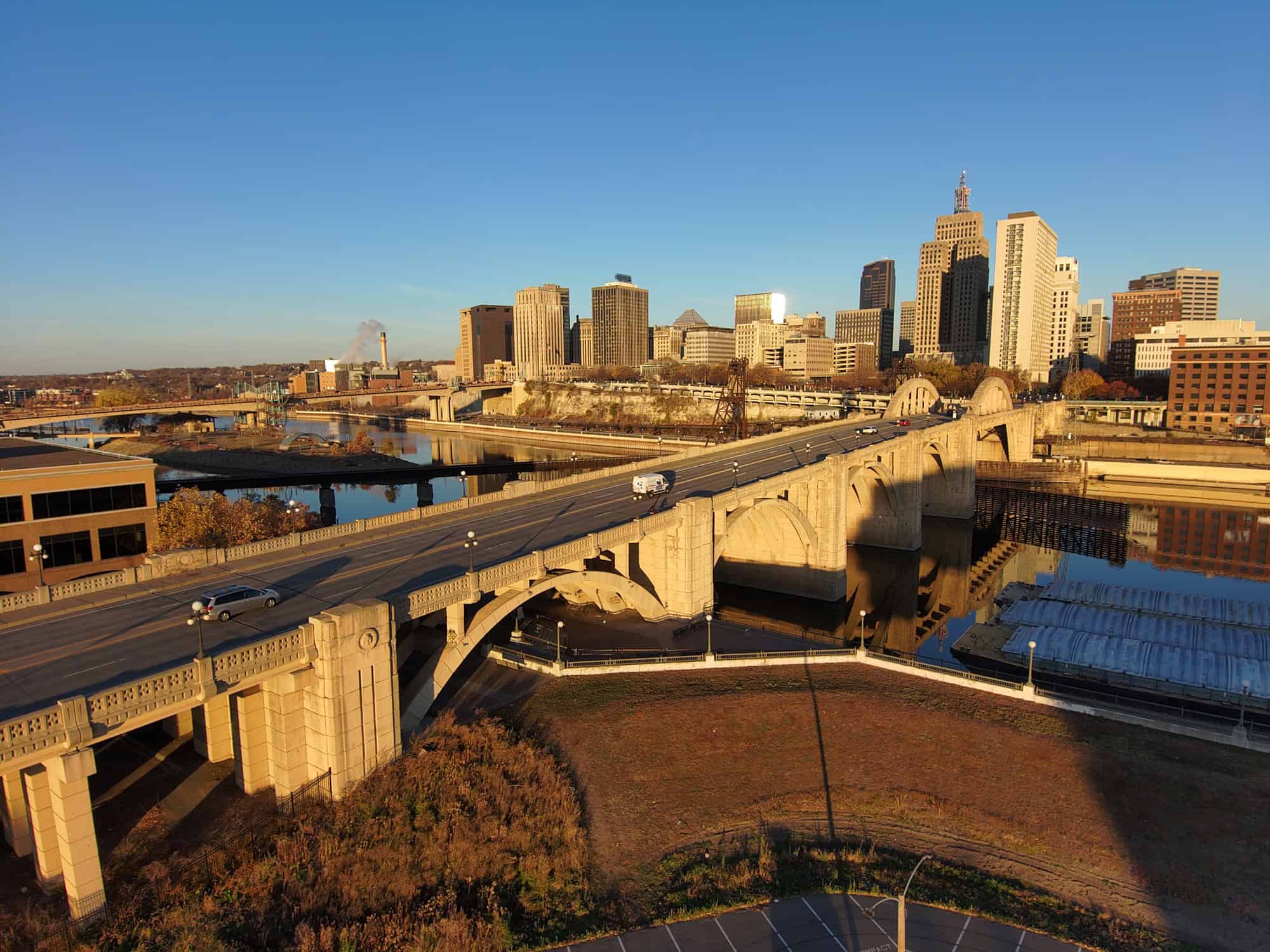
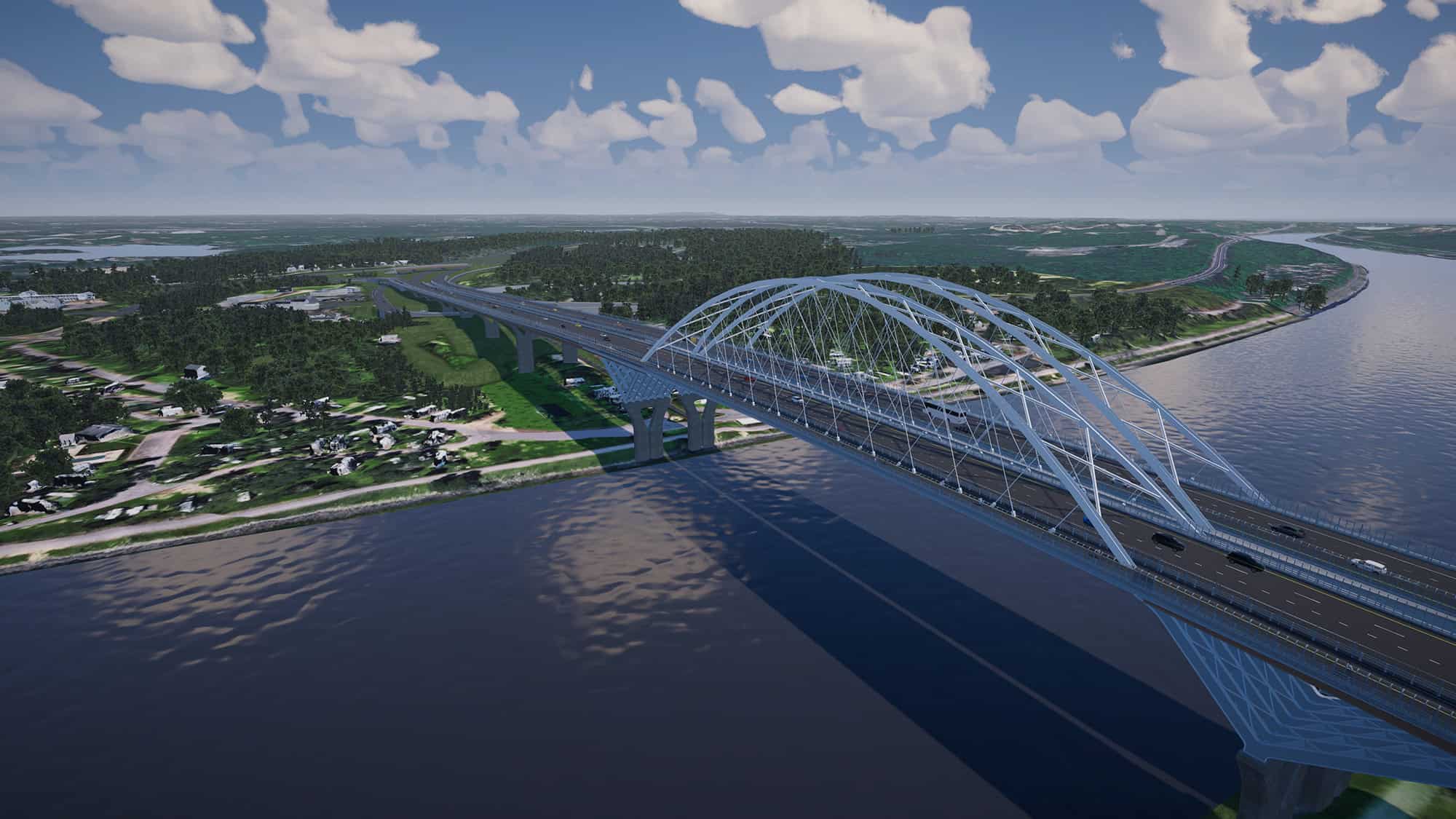
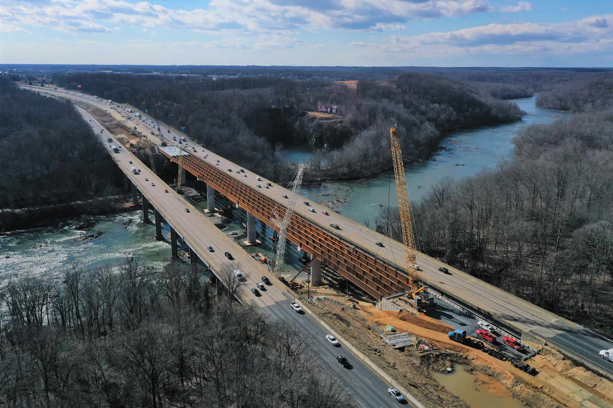
Aerial view of a bridge along a highway overpass along the span of I-95 over Rappahannock River.

The plan had to solve a complex puzzle. To handle growing local traffic in and around the city of Fredericksburg, planners added six miles of new southbound lanes in the existing median of I-95. Then they converted the original southbound lanes into a collector-distributor road, a parallel roadway to separate through-traffic from local traffic between major exits. The redesign required four new bridges, including a 1,200-foot span rising roughly 100 feet above the river; a new crossing over Route 17, a major regional arterial highway; and two replacement bridges at the existing interchange of I-95 and Route 17.

JMT began building a detailed 3D model early in the process to utilize as a working environment—one that could absorb engineering data, environmental constraints, and design alternatives as they evolved.

When the Software Starts Working Together

3D model of a bridge spanning a river in a landscape, displayed on design software with project details and file navigation panel visible.
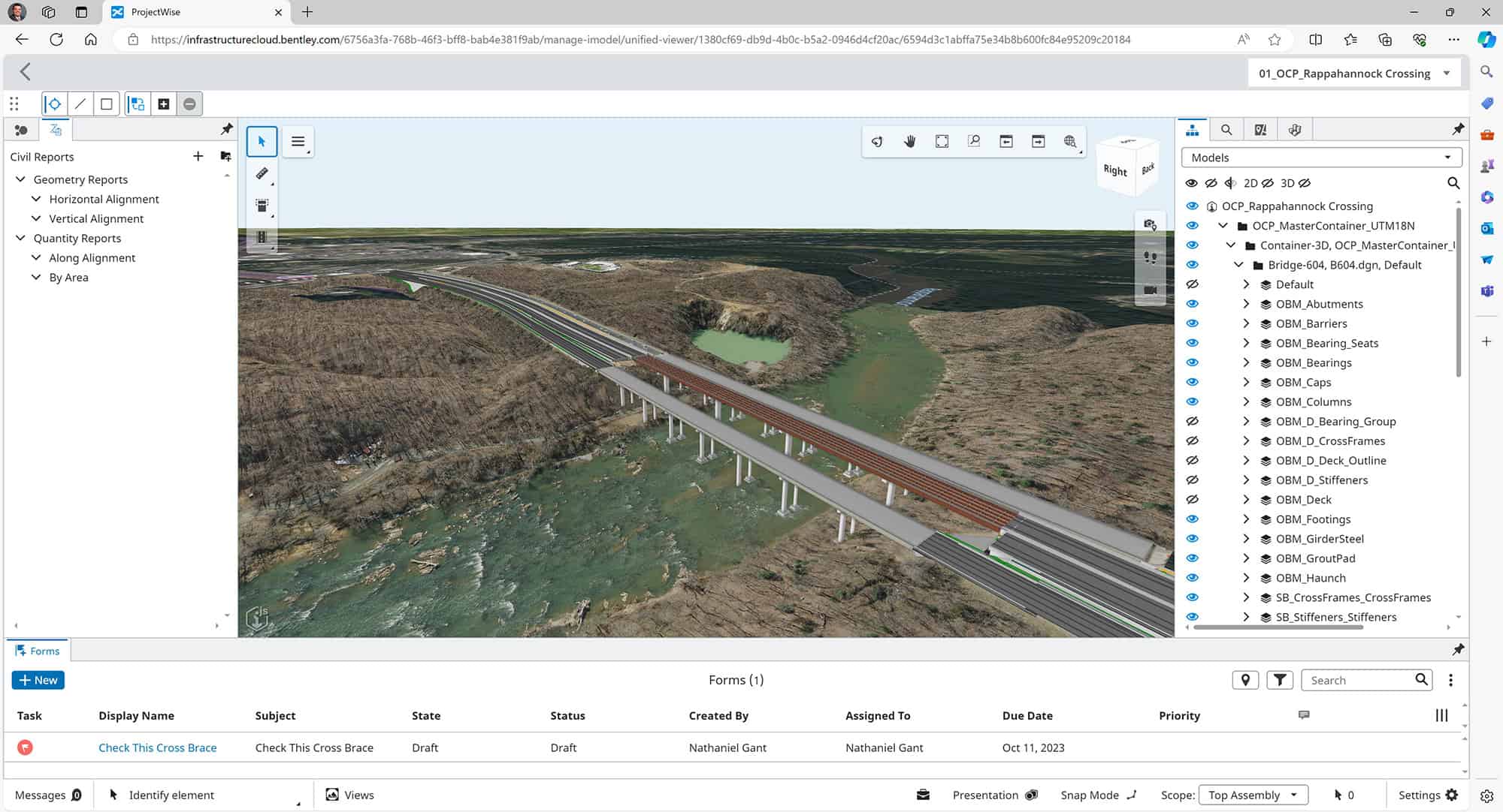
ProjectWise Infrastructure Cloud model of Rappahannock River Crossing.

This is where technology developed by Bentley Systems, the infrastructure engineering software company, enters the story—as a connected system, not just a single tool. JMT used Bentley’s ProjectWise as a common data environment to keep engineers, planners, and partners aligned around live information instead of copied files. Bentley’s OpenRoads and OpenBridge fed the core model with engineering-grade detail. That model then flowed into the iTwin Platform, where it could be viewed, shared, and analyzed in a web browser—no specialized software required.

For public agencies accustomed to static PDFs and slide decks, the shift was immediately embraced. Stakeholders weren’t just being told what the project would do—they could see, rotate, and question it. Then to bring broader context into the picture, JMT used technology from Cesium, the 3D geospatial company that Bentley acquired in 2024, to place the model within its real-world geography. Historical features, environmental boundaries, and even sightlines from nearby neighborhoods became part of the conversation.

The result was something closer to a living system than a set of drawings—a digital twin that evolved as decisions were made.

Turning Skeptics into Participants

The big payoff came during public engagement.

Virtual public meetings for the Rappahannock project drew roughly three times the attendance of traditional in-person sessions. Residents who might never have shown up to a town hall logged in to explore the project on their own terms.

At JMT, the emphasis wasn’t persuasion. It was comprehension. ā€œI’m an art school kid who somehow found his way into an engineering firm,ā€ says Vince Novak, JMT’s director of digital experience. ā€œEverything we do is user-focused.ā€

That philosophy shows up in unexpected ways. For a roundabout project in Ohio, JMT embedded its Bentley-based models into a gaming engine, creating a driving simulator. Residents could navigate the intersection virtually—whether in a sedan or a tractor-trailer—before a single yard of pavement was poured. On other projects, tablets allowed residents to stand on their doorstep, point an iPad down the street, and see exactly how a future bridge or roadway would change their view.

The technology didn’t eliminate disagreement. But it changed the tone. Questions became more specific, and concerns became actionable.

A highway overpass with cars traveling in both directions, labeled signs indicate I-95 South to the left and I-95 North to the right; trees and buildings are in the background.
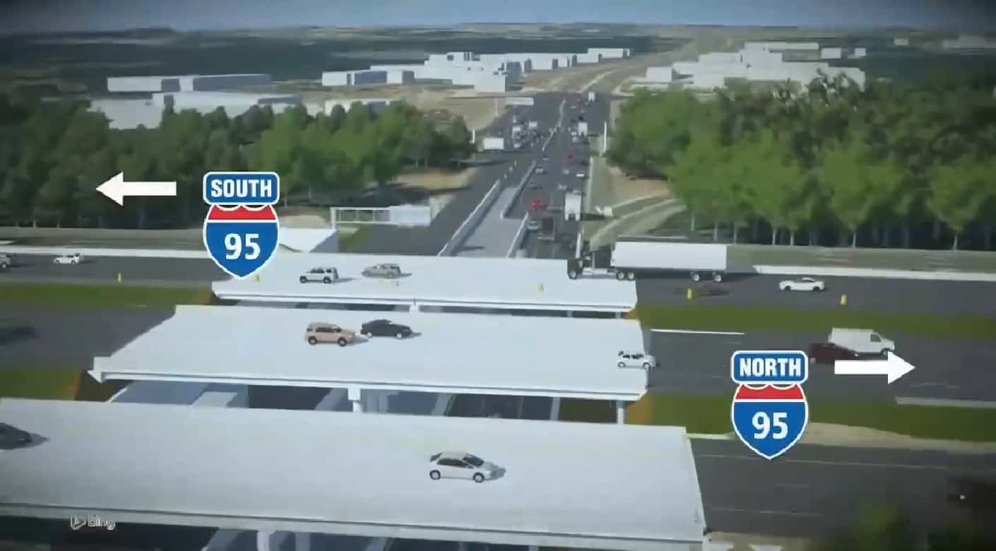
3D visualization of a highway overpass along the span of I-95 Rappahannock River Crossing project.

A Model That Doesn’t Retire

When construction begins, most models fade into the background. But at JMT, they stay live.

The same digital foundation used for planning and engagement becomes the basis for construction coordination, then inspection, then long-term asset management. Drone-captured reality data feeds back into the iTwin Platform, creating an evolving record of the asset as it exists—not just as it was designed. The model can take in overlay inspection data, track change over time, and identify risks before they become failures.

This is where artificial intelligence (AI) enters the picture. High-quality, well-structured models are what make future analysis possible through AI, whether that’s condition assessment, disaster simulation, or predictive maintenance. ā€œA better model tells a better story,ā€ says Maria Gruzynski-Martin, who leads technology business development at Bentley. ā€œAnd it keeps telling that story long after construction ends.ā€

Bentley recently made two acquisitions that give its Asset Analytics business new AI capabilities.

What the River Crossing Taught Them

The Rappahannock project succeeded because its complexity was made visible—and shared. For JMT, the lesson was that digital delivery isn’t just about speed. It’s about alignment: engineers, agencies, communities, and data working from the same source of truth.

ā€œThe advanced modeling capabilities, built-in analysis, and simulation tools of Bentley applications allowed our engineers to efficiently assess the management of traffic, performance, safety, and sustainability of the proposed roadway designs to help identify potential issues early in the design process, thus saving time and resources,ā€ Donahue said.

In 2024, JMT submitted the project for the Year in Infrastructure and Going Digital Awards, dubbed the Oscars of infrastructure, and won in the Bridges and Tunnels category. For Bentley, the project and its recognition reinforced that when software is open, connected, and designed to work together, engineers can focus less on managing information and more on solving problems.

And for drivers who cross the Rappahannock River every day, the benefit is simple: infrastructure that works, and their voices were heard before it was built.

Relevant Tags

Transforming the Port of Melbourne with Bentley Software Repurposed from The B1M by Kathleen Moore Melbourne is Australia’s largest container ...

In July 2022, Ben Shinabery watched the news with growing unease as a deluge of rain—up to 16 inches in ...

One day a decade ago, when Mark Pittman was a student at The University of Utah in Salt Lake City, ...

Subscribe to The Bentley Brief

Stay ahead of the curve with the latest infrastructure news and insights.